Saturday, a week ago, the 25th of August, we got an early start and drove to the Porcupine Mountains at the far western end of the U.P. It's a journey of about 100 miles each way, so the early start was essential if we were to spend any time there.
The western half of the U.P. is more interesting to drive through, as it's higher and has more hills and elevation changes. Nonetheless, it's still a hundred mile journey and you find yourself looking for anything that moves and reading every sign along the way. One sign was notable for it's bold display of Yooper-ism. It was for a small bar and grill in Kenton. The name of the place was "UP Chucks".
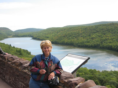
A little about the Porcupine Mountains Wilderness State Park: It's about 60,000 acres of mostly original old-growth forest that grows on the sides of a couple large, steep-sided escarpments, that run parallel to the shore of Lake Superior. From the water the area supposedly looks like a sleeping porcupine and it was named such by the Ojibwa Indians. It's about 26 miles long and 10 miles wide. When most of the area was logged off in the early 1900's, it was difficult to near-impossible to access most of this timber with the logging equipment of the time, and was left more or less undisturbed. One of the most popular features of the park is "Lake of the Clouds", a large lake nestled between the two escarpments and visible only by foot. I'd like to tell you that we hiked through 5 miles of rugged terrain to see it, but the truth is the forest service made it relatively easy to drive to within a few hundred feet of an overlook. That's where this picture was taken...
Since the park is right along the Lake Superior shoreline, there are also some spectacular views of the lake, the rocky shoreline, and, off in the distance, the Apostle Islands National Lakeshore about 35 miles to the west northwest.
The park contains a lot of grand old examples of Eastern Hemlock, Yellow Birch, and Sugar Maple. A number of rivers begin and end within the boundaries of the park. Summit Peak is the highest point in the park, at 1953 feet above sea level, and was thought to be the highest point in Michigan until the late 50's when more accurate equipment identified another point in the Huron Mountains, about 25 miles due north of Camp Soldner, as the highest point at 1979 feet. The 90 or so miles of hiking trails that snake through the park make it popular with dayhikers and overnight backpackers alike. The North Country Trail, that stretches from New York to North Dakota, also runs through the park.
Wildlife in the park consists of almost anything you can imagine in this part of the country... deer, fox, coyote, wolf, smaller varmints, and bear. Despite giving Dar a open pot of honey to carry around, we never saw any bear.
Due to the elevation changes there are a number of waterfalls in the park. Some off the best are along the path of the Presque Isle River as it makes it's way along the western border off the park before it dumps into Lake Superior. Near it's mouth the river splits and leaves a small chunk of land that's an island during the heavy spring runoff but, as the water flow eases during the early summer, the water takes only one path leaving the other dry and that chunk of land is not an island for a while. Presque Isle is a French phrase that means "almost an island" or "sometimes an island". The water flows over rocks that were formed by volcanic activity over a billion years ago. One type of rock is called "nonesuch shale", which is relatively soft and layered like you'd expect shale to be. When water runs rapidly over this soft rock, carrying smaller bits of sand and rock with it, the shale wears away -- sometimes in unusual and stunning ways. Where falling water creates eddys, swirling currents, "pot holes" are formed. In the photo below, the two kayaks are sitting on top of a large pot hole and other smaller ones are visible around the edges of the rocks.

Feeling a little ambitious, we hike a few miles north and south of the Lake of the Clouds, then had a picnic lunch to recharge the old batteries. Then a hike to the top of Summit Peak where Dar had a problem with the wooden observation tower... "too high" she says. After another stop at yet another waterfall, we spent a good deal of time hiking and shooting pictures around the lowest three waterfalls. I had the GPS along and figured we walked about 5 miles all day, but it felt like twice that with all the steep trails. I don't think the GPS measures verticle mileage, does it?
The Porcupine Mountains Wilderness State Park is highly recommended on our list. For hiking, backpacking, or just soaking in the sights of an original old growth forest and the largest lake in the world, we haven't seen better. We're figuring out how to get back here earlier some year when the waterfalls have to be incredible during the spring runoff.
T
Thom and Dar....that is an outstanding picture of the Kayaks in the large pot hole!!!
ReplyDeletesh