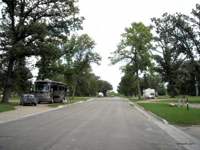
As I mentioned in my last post, the Sherlock Campground in the Red River State Recreation Area was a residential neighborhood prior to the big flood of 1997. When the water receded and plans for higher levees were drawn up it was determined that this part of town was just too low to be adequately protected from future flooding. The owners of these properties were bought out, the homes, which had been severely damaged by the record flood, were removed, and the land became part of the new State Recreation Area.
The streets through the campground are the very same ones that carried traffic through the neighborhood. In many areas, the sidewalks also remain. Between our camp and the downtown commercial/entertainment district, only two or three blocks away, is a new levee that now protects East Grand Forks. I climbed to the top of that levee and pointed the camera down 2nd Street toward downtown (the dry side of the levee), to the southeast. The second picture is from the exact same spot but toward the old neighborhood in the opposite direction.
 |
| 2nd Street looking southeast into downtown from levee |
 |
| 2nd Street, looking northwest into campground from levee |
 |
| Bridge between Grand Forks and East Grand Forks during flood. |
 |
| Downtown Grand Forks during flood of 1997 |
It's been estimated that about 3% of Grand Forks' population relocated away from the area in the months and years after the flood. But in East Grand Forks it was more like 17%.
Dar and I, during our limited time here, have found the area vibrant and refreshing. It's rare indeed that we eat out two nights in a row, but that's exactly what we've done. Monday night it was the Blue Moose and last night it was Whitey's, an East Grand Forks institution since 1925. According to legend, Al Capone (yeah, that Al Capone from Chicago) was involved in the original ownership of Whitey's. I can't vouch for that, but can report we really enjoyed both places.
We're extending our stay here one more night in order to get laundry caught up. It may be some time before we have full hookups again and the supply of clean underwear was near critical level. On Thursday we'll head west again.
Getting the bikes ready for a long ride along the river...
T


Amazing pictures and story, Tom. I'll put that on my list of "future sites to see." Neat!
ReplyDeletethanks
Paul
wheresweaver.blogspot.com
Another interesting post, great historical background. I like the nice roads in the campground, what a good use to put the land to.
ReplyDeleteThanks to both of you. It really is an uplifting story of how an area dealt with such adversity and was able to come back with such vigor. I hope you stop and check it out for yourselves when you're through this area.
ReplyDeleteT