Aug 16, 2015

News from the North - August 9 thru August 15

The first half of this week we were in Haines. Thursday we left, and felt the melancholic divide that separates being on a trip from heading home. It's true, there's still much new territory to explore, but there's no way around the fact that we're closer to home with each day's drive.


Sunday, August 9 - Kathleen Lake on the Haines Highway to Haines (day 64)
Kathleen Lake CG

Broke camp and headed south to Haines. Along the way we checked most of the campgrounds for future reference. This is another out-of-this-world drive that words can't adequately convey. At times you find yourself taking it all for granted. Then, when you stop and think about what you're seeing, it's like your seeing it for the first time. One of the great views (I know... there are so many) here in Alaska is to see Chilkoot Lake from the State Park. Encircled by mountains, it Alaska at its best, geographically speaking.

Between Haines Junction in Canada and Haines in the USA, we crossed two borders on the short 150 mile drive. First, from Yukon Territories into British Columbia and then from BC into Alaska in the US. Keeping all these border and customs facilities open must be a real task.

Nearing Haines, the road closely follows the very wide, silty, and braided Chilkat River. Most of these glacier-fed rivers are full and flowing hard... the result of long warm days melting the mountain ice. This is also a bald eagle sanctuary as thousands of the big birds stop here for salmon snacks on their way south in October.

In Haines we made quick work of a few sequential tasks. First, was to see if we could book passage on the fast day cruise down to Juneau. Not cheap, but not sure when we'll be in a position again to see Juneau and one more state capitol. We got that booked for Tuesday.

Then, we made reservations at the Oceanside RV park for Monday and Tuesday nights. Time again for some laundry, showers, and a good battery charging. It also places us within a block of the boat dock for our Tuesday outing. No need to break camp for our cruise.

And on our way out to Chilkoot Lake State Park campground, stopped at the ferry terminal to see about the ferry to Skagway. Didn't book anything, but did confirm they have room for us if we choose to go that way.

On the way out to the State Park, we follow the Chilkoot River for a ways. It was very busy with people fishing and watching for bear. Very busy. Made us a little concerned that the campground might be full too. But there was no reason to fear... the campground had space for us. We made camp and called it a day.

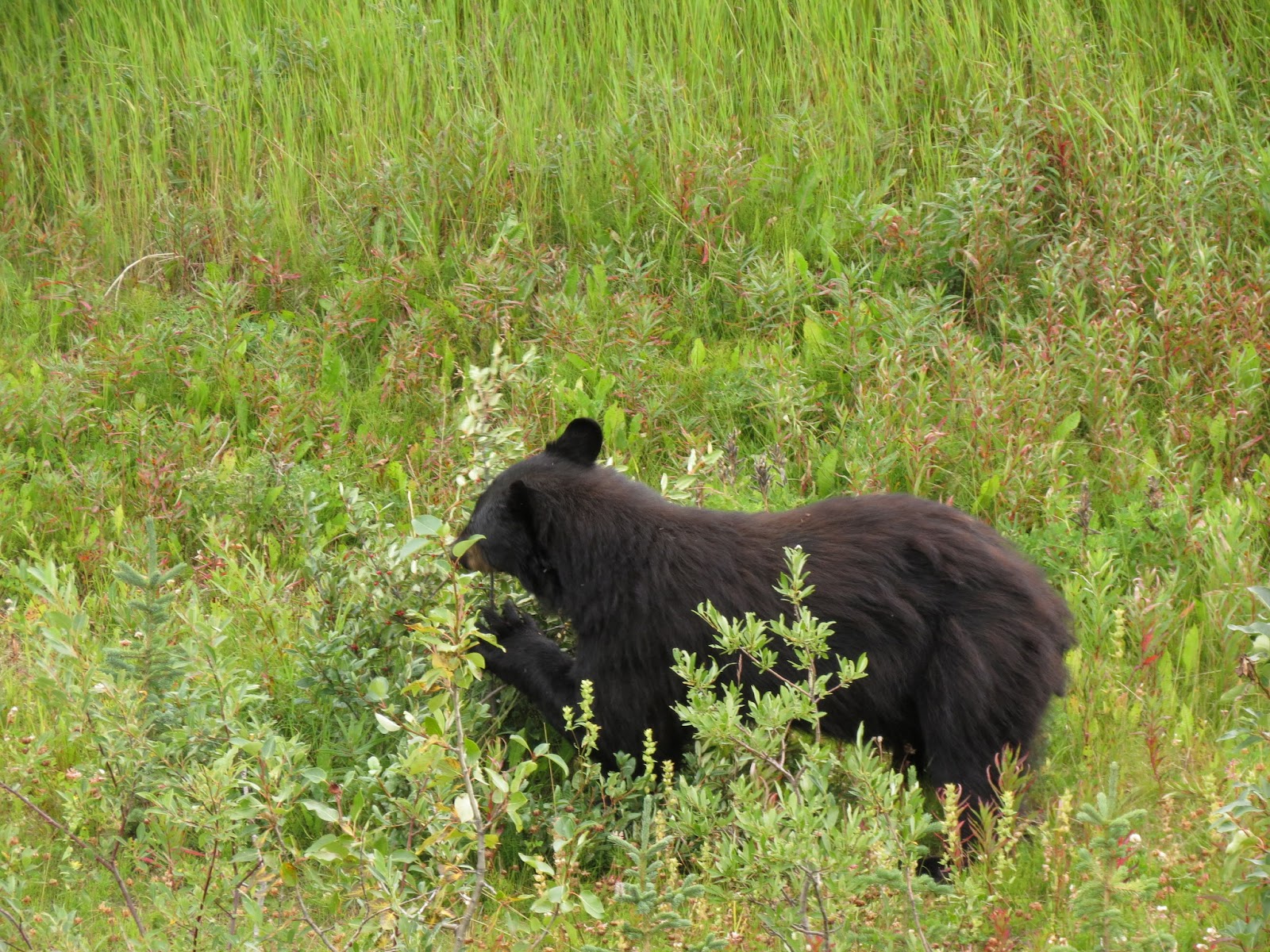
black bear lunching on roadside fodder

our camp at Chilkoot St. Park outside of Haines


Monday, August 10 - Haines area (day 65)
Chilkoot Lake SRA CG

Rained overnight and into the morning. Moving to the RV park for a couple days for the usual reasons, and to be parked close to the city docks for our boat cruise to Juneau on Tuesday.

Was noon by the time we broke camp. On the 9 mile drive back to Haines, Dar kept a lookout for brown bear feeding on salmon in the river. And she spotted one, actually three... a large sow with two cubs. Just had to stop for that show. Got some good picks too.


According to a local, this is a familiar bear to the residents of Haines. Her nickname is Speedy. She recently was tranquilized so a large fish hook could be removed from her nose. Guess the two little ones also got a trip to la la land while their mom was worked on. She probably got the hook in the process of fishing herself, but it made me smile to fantasize that some unlucky fisherman hooked her while fishing... and got much more than he bargained for.

We stopped at the Rusty Compass for lunch... a small local cafe. Had a splendid time talking with the two brothers who own the joint, as well as other customers who wandered in. As far as I'm concerned they've also got the best WIFI in town.

Then it was out to the fairgrounds where we visited Dalton City, the movie set where the movie White Fang was shot. It also just so happened that the current home of Haines Brewing Company is located in one of the movie set buildings. We joined a steady stream of fellow beer connoisseurs eager to sample their concoctions. It's a lean efficient operation evidenced by the fact the owner and head brew master, Paul, was the one who waited on us. He was enjoyable and a wealth of knowledge on beer history.

We also ran into a couple that's going to be on the cruise to Juneau with us tomorrow.


Tuesday, August 11 - Haines area (day 66)
Oceanside RV Park

On the road to Juneau.

Wait! There are no roads that go to Juneau from anywhere else. The only way in or out is by plane or boat. Literally everything there, everything, had to be brought in from outside.

Set an alarm last night to insure we'd be up for the boat, but didn't need it. Out the door and into a seemingly persistent, perhaps permanent, light rain for the short walk to the dock. Walked right onto the boat and took seats near the front on the starboard side.

The Fjordland is a one-of-a-kind boat. She has no sisters. Glen, the owner commissioned it's design and construction about 15 years ago. With a true catamaran hull, it sits low in the water drawing 5 feet, and cuts through the chop and roughness of the inner-passage waters like a hot knife through butter. A much smoother ride than we were expecting. She can do close to 30 knots and today we were running at 26 knots. Has two 600hp Lugger diesels. Passenger capacity of about 50. We covered the 70 miles to the Juneau area in two and a half hours.

The geographic area of Juneau is immense... the second largest city in square miles in the entire USA. Of course, most of that area is wild and undeveloped... annexed by the city for some control over mineral rights. The population is only 32,000. The people of Juneau are used to rain... don't even notice it... as on average it precipitates 320 days per year. It gets, on average, 8 feet of rain plus 8 feet of snow.

A bus met us at the dock about 30 miles north of the city center (but still within the borders of Juneau), and we enjoyed the ride with a knowledgeable and humorous bus driver of English descent from Utah. We had about 3 hours to explore once off the bus.

First up was lunch. With 4 (that's right, four!!!) huge cruise ships in town, the place was crawling with tourists. We found a mildly busy fish joint called the Twisted Fish and had a lunch of local halibut fish and chips, washed down with some tasty craft beer.

The Alaska State Capitol
Then, on to the Capitol building... one of our main reasons for making the trip down here. Nothing is very far away in Juneau and it's a walkable distance even in the rain. Unfortunately, most of the building was off limits due to a large reconstruction project that won't be completed until 2017. We did meet our own requirements for having visited another state capitol, got a few pics, and left. It's not a very impressive building... a 4 or 5 story block office building with a little ornateness here and there on the exterior. The bus driver joked that this Capitol consistently ranks 50th among capitol buildings of the USA. We beg to differ. Florida's is still the ugliest Capitol that we've ever seen.

To kill a little time we stopped at the Alaskan Hotel pub.

Mendenhall Glacier (left) and Nugget Falls (right)
Soon we were back on the bus for a drive out to Mendenhall Glacier. On the way into the park we got a little show from a mama black bear and her cub. They crossed the road right in front of us.

During the hour we spent at the Glacier, we hiked out to Nugget Falls... about a mile each way. Recent heavier than normal rains had the falls roaring. In an effort to get closer we took a path through a creek, complete with randomly placed rocks on which to hop across without soaking your boots. Always one striving to provide entertainment and make people laugh, I was successful at this at least, if not staying dry, by loosing my balance on a tippy rock and doing a backwards ass-dunk in the creek. No injury except to my pride.

A humpback giving us a show

On the boat trip back we had a little more time to look for whales. And find them we did. We'd seen humpbacks in Prince William Sound while aboard the Lu-lu Belle, but we happened upon a group today that gave us a real show. They'd lay on their sides and slap the water with their huge pectoral fins. They'd breach, sometimes almost completely out of the water, not once but dozens of times. Big ones, small ones... they looked like they were having a party. What a treat.


We met a young woman today named Sionaid. But in her 20s, she's taking a few years to travel and see the world. If we ever seriously think we're living an adventurous life on the road... with our motorhome and truck camper, thoughts of Sionaid will snap us back to reality. She's been living now for a year out of her backpack and taking advantage of public transportation and serendipity to move from place to place. It's really all about attitude, isn't it? OK, maybe youth plays a role too. But when you're coming from a paradigm of a mini-mansion house hooked completely to the grid, automatically climate controlled, entertainment systems, multiple refrigerators, walk in closets, and so much space for all your stuff... all the comforts so many of us have come to expect, it's hard to understand the freedom and enjoyment of traveling light.


Wednesday, August 12 - Haines (day 67)
Oceanside RVP

Surprised somewhat that it hadn't rained overnight. But the dry spell didn't last. Most of the day it dribbled.

Kind of a chore day today. Not planning anything much. The RV park is hosting a crab potluck tonight. We did walk up to town for a few vitals, a "dish to pass" for tonight's potluck, and a dose if internet at the Rusty Compass.

The crab boil turned out very nice. Met more travelers with whom to share stories. This is the end of crab season up here, so this'll be the last crab feast of the year.


Thursday, August 13 - Haines to Dezadeash Lake (day 68)
Oceanside RVP

A more rushed morning than usual for us. We're leaving today and taking Sionaid to ferry terminal on the way out of town. My new little Nikon camera turned up missing this morning. Assume it was picked up by someone after the potluck dinner last night... hopefully a case of mistaken identity and not outright theft. Regardless, we're moving on without it. (Correction: Saturday night Dar unrolled her camp chair/sleeping pad and out rolled the camera. Lost is found. Sorry for the negative thoughts and assumptions about fellow travelers)

The day broke bright and clear. The sun felt so good. Best weather day during our stay. The surrounding mountains were stunning. Visibility must have been a thousand miles. Can't express how clear and distinct it was. Southeast Alaska gets very few days like this during the typical year. We're happy we could share one of them.

Drove north out of Haines, crossed the border into BC, and short while later, into the Yukon.

Stopped and lingered at a wayside not far from Haines Summit. Had lunch and soaked in the views. As we drove along Dezadeash Lake decided to go in and check out the campground. Even though it was early, decided to drop anchor and enjoy the bright warm day.


Camp on Dezadeash Lake

Friday, August 14 - Dezadeash Lake to Whitehorse YT (day 69)
Dezadeash CG

Of all the travelers who stay one night in a campground during their trip to somewhere else, we're usually the last to leave. What's the rush? About 30 miles north to Haines Junction where we pick up the Alcan again.

This, the road from Haines Jct. to Whitehorse, is the last section of the Alaska Highway that we've yet to drive. An easy road with a generally good surface and minimal grades and curves that traverses a wooded landscape backed by distant mountains. The highway route is cleared of trees and brush for a wide margin on both sides. For much of the way an earlier alignment of Alcan is clearly visible to the south.

We stopped at the junction with the Klondike Hwy to toast our completion of the Alcan... the Alaska Highway. From Dawson Creek to this point we did northbound. From Delta Junction to here we did southbound. The section from here to the Casiar we will have done both ways. It was a major bucket list item... and now it's finished. Mixed feelings about that. Glad we did it, but hate seeing the bucket list getting shorter. We must find some new things to add.

Since we stayed there on the way north, we knew the closest government campground to Whitehorse so we headed directly there. The other options are RV parks or Walmart. Wolf Creek CG is used a lot by locals and with this being a friday, we knew sites might be hard to come by. We arrived about 2pm and snagged the last open site. And not a bad site at all... sorta away from the large family groups and partiers. Lit a fire, savored happy hour, cooked dinner on the coals.


Saturday, August 15 - Whitehorse YT local (day 70)
Wolf Creek CG

Decided to extend our stay here for another three nights. Would like to see more of Whitehorse. That'll have us leaving on Tuesday. After scrounging together the correct change for the campground self-pay envelope, we drove into town. Stopped first at Yukon Brewing. Liquor laws in the Yukon are not conducive to a proper and satisfying craft brewery visit, but we made do with the tiny samples they had available and bought a few cans for the supply room. We're huge fans of craft beer in cans. It fits our system much better than bottles. More volume can be kept refrigerated in a smaller space, empty cans are much easier to deal with while traveling or out on a trail, and, really, cans are a superior package for beer.

The grocery store was next. This is our best bet for a full-size grocery for the next week or more, so we loaded up. Prices up here are high. How high? A guess, based on a few items I know we regularly buy in the US, is maybe 30 to 50 percent higher. The current exchange rate moderates that a bit, but it's still a penalty that must be paid to live in the far north.

Decided to do a hobo dinner on the campfire tonight. One hour of effort to keep the heat about right with fast-burning wood that didn't want to cooperate resulted in near perfection. Dar made the right amount and we ate the entire thing up with nary a scrap left over.

Aug 10, 2015

Dispatch from the North for the week Aug 2 thru Aug 8

An Ice Rose Globe... all from solid ice.
The Fairbanks area was our focus for the first half of the week. As we began our southeasterly trek on Wednesday it really felt like the beginning of our trip home. The next few days had us camping in a series of government campgrounds both in Alaska and Canada.

Sunday, August 2 - Fairbanks (day 57)
Tanana Valley Campground

Stayed home today and worked on blog and photo stuff. Sometimes you just gotta have a “down” day to recharge the batteries (both the camper’s and mine), loose yourself in the pages of a book, and experience a little solitude.


Monday, August 3 - Fairbanks to Chena Hot Springs (day 58)
Tanana Valley CG

Decided to go up to Chena Hot Springs today. Some travel guides say this is a must do in the Fairbanks area.

The hot springs are northeast of Fairbanks on a good 50 mile long road that dead-ends at the destination... about an hour and a half drive with a few stops along the way. Because there's minimal traffic, especially on a Monday, it was an especially relaxed and enjoyable drive.

Chena Hot Springs is really a complex complete with lodge, restaurant and cafe, activity center, an ice museum, air strip, reindeer herd, it's own power plant... all in addition to swimming pools, hot tubs, and a large rock-line outdoor soaking pool where we spent much of our time.

Besides a soak and long hot shower... we had lunch and then did the ice museum tour. A couple from the area (ref) have a workshop in the building and create these large and intricate ice carvings. These are true art pieces and these two are real artist. The results are nothing short of spectacular. Because this art must be frozen (obviously), sublimation (ice changing directly from solid to gas... skipping the liquid phase) is an issue. But due to the museum's policy of limited entry and consistent temperature and humidity, it's a slow process. Our guide pointed out two longer term items... one 5 and the other 11 years old. Both have had a few finer features (like a finger) replaced due to sublimation.

Dar at the "ice bar" in the ice museum.
Everything in the museum was made of ice including two ice motel rooms; an ice bar (where they served real appletinis in carved ice glasses); and an ice altar where couples can (and do) get married once in a while. The two ice artists made it for their own wedding. These ceremonies tend to be sh... shh...ort. For some, it's appropriate that their life together starts out chilly. For the tour, the museum provides one-size-fits-most coats, Tour lasts about an hour and costs $15.

On the way out to Chena Hot Springs we had checked out a couple state campgrounds, which were neat, maintained, and perfect for our needs. But we also learned there's a number of other places where we could drive down to the river (the Chena River, of oourse) and camp on a gravel bar. And that's what we did. Tonight, we're hard on the banks of the North Fork of the Chena River, across from the Granite Tors campground.


Tuesday, August 4 - Chena River camp to Fairbanks and North Pole (day 59)
Gravel bar on North Fork Chena River off Chena Rd.

Getting cooler at night. Saw 46 early this morning. But the same clear sky that let the heat escape will make for quick warming as the sun climbs this morning.

We drove back to the Fairbanks area on Chena Hot Springs Road but made a slight detour a few miles north on the Steese Hwy to a Trans-Alaska Pipeline viewpoint. Could wander around and under a few hundred elevated feet of the beast that was built in the mid 1970s. It was quite an engineering achievement as provision had to be made to keep the hot oil (about 100 degrees at this point on it's 800 mile trip south) from melting the permafrost. Wherever the pipeline traversed permafrost it is above-ground and supported on structures designed to dissipate heat and keep the ground frozen. The 48" pipeline itself is wrapped with insulation too. Due to the normal production decline over time of oil wells, these days the line is currently at less than 50% of it's full capacity.

After a foiled attempt to have lunch at the Silver Gulch Brewery (didn't open till 4pm), we next headed to the University of Alaska Museum of the North. An informative and entertaining experience, we immersed ourselves in geophysical, cultural, and historical aspects of the 49th state. If you're at all inclined to seek out mind broadening things like this, I'd highly recommend stopping.

Burdened by that parched throat one tends to get after a couple hours in a museum environment, we sought, and found, Hoo Doo Brewing's brewhouse and taproom. It didn't open until 4pm, but we're slightly surprised when we drove in and had a tough time finding a place to park. It's situated in an industrial area and their parking lot has room for maybe a dozen cars or so. Others must park alongside area roads and walk to the "hoppin" (intended) joint. Despite the crowd, it didn't take long for them to pour a couple of their finest craft creations and we found a spot at a large cable reel table to kick back and relax. I was assured by the staff that this was not an exceptionally large crowd. The place really gets going on weekend nights. Definitely one of the places to be in Fairbanks.

Time to find camp. Dar had picked a state recreation area near North Pole called the Chena Lakes Project to check out. This was a COE project constructed after the Chena River flooded big-time in 1967... almost wiping out all of Fairbanks in the process. As the COE tends to do, in addition to all the diversion channels, lakes, and dikes, they included serveral recreation areas for the public. This included two very nice campgrounds. We found a spot in the Chena Lakes CG and dropped anchor for the night.


Wednesday, August 5 - North Pole to Big Delta on the Alcan (day 60)
Chena Lakes CG

First on the agenda this morning was a stop at the Santa Claus House in North Pole. I did not go in, preferring to wait in the truck, work on my blog post for the week, clip my fingernails, and think a little about income tax strategies for 2016 .

Rika's Roadhouse
This part of the Alcan isn't it's most scenic. Low wet marshy areas and tree-lined forested areas kept the camera shutter cooler today. The road follows the Tanana River through here. We stopped at the Big Delta State Historical Park where the road, now and historically, crosses the river. There's a preserved roadhouse here called Rika's Roadhouse that assisted travelers with lodging and supplies for many years. It was also the location of a communications facility used my the military in the 20s and 30s. We lingered, perused the roadhouse and surrounding grounds, and found a piece of pie to fill that afternoon craving one gets from exploring.

Slow as she goes... decided to make camp tonight a couple miles north of Rika's at Quartz Lake State Recreation Area campgound.


Thursday, August 6 - Big Delta to Tok on the Alcan (day 61) Quartz Lake CG

Rained overnight. At times, heavy. But despite all the overnight commotion, we woke to clearing skies and some sun. I like this rain schedule... more or less clear during the day with rain at night. All right.

The big wildlife sighting today was just outside the Quartz Lake campground where a large cow moose strolled out of the woods and right in front of the truck. "Moose!!" She began trotting ahead of the truck in an effort to get away from us and eventually angled back into the cover of the woods. A second cow, a little smaller than the first, could also be seen just on the edge of the trees. Of course this all happened so fast Dar could only get a couple quick shots of the first one. But it was, I believe, the closest and best moose sighting during our time in Alaska.

Stopped at the visitor center in Delta Junction... at the official end point of the Alaska Highway and took a few pics. The historic Sullivan Roadhouse is right there too, and we paid a short visit there as well. We missed a big section of the Alcan on the way up a month ago, between Whitehorse YT and Delta Junction AK, when we went north on the Klondike to Dawson City. But our intention is to drive every mile if we possible can.

The 100 miles between Delta Juction and Tok went by quickly, but an old nemisis plagued us again today. Just as the last time we were in Tok, smoke from wildfires was fairly heavy. It degraded the great views of the Alaska Range of mountains to the south of the road. Some day, we'll actually get to soak in these views on a good crystal clear day. Based on what we could see through the smoke today, it must be awesome.

In Tok, we refueled ourselves and the truck, and then headed for another State campground... this one was Tok River SRA. Found a good site along the river and made camp for the night. During the day the weather cleared even more, the wind picked up... brisk out of the northwest, and the temps dropped a few degrees. Should be a good sleeping night.


Friday, August 7 - Tok to Destruction Bay on the Alcan (day 62) Tok River SRA campground

On the Alaska/Canada border... note the alley of
cleared trees in the center of the pic. That's the border
and it's a cleared alley for as far as one can see.
From Tok to the border, the road is decent, about what we've come to expect from the Alcan. But after our border crossing into Canada things changed. From Beaver Creek to Burwash Landing it's a mess. We were glad we made the decision to bring the little camper on this trip... here again, it can't be enjoyable to pick and swerve a big rig around potholes and rough areas of construction. So many people have told us we did the right thing to bring the small rig.

There's a long term project, partially funded by the US, to completely rebuild the Alcan from Haines Junction to the border. Apparently, it's going kinda slow. There were many miles of gravel road in the "constuction zones"... but many of those miles hadn't been worked on for a long time, and areas of potholes and very rough gravel surface were common. Even though we had to wait up to a half hour for a pilot car to lead us through some long stretches, we didn't see evidence of much work going on. It was the most nerve rattling and frustrating area we've encountered on the Alcan.

By the time we reached Destruction Bay we were ready to make camp. A good source led us to Congon Creek CG a few miles south of Destruction Bay... and they were right. Perfect for us. Set up camp, lit a campfire (free firewood!!), and settled our nerves.

Oh, along the way today, we stopped at a visitor center in Beaver Creek, where we met two of the most enjoyable hosts we've run into in a long while. Free with the "insider" information, we got the straight skinny on all the nearby goings-on. They even offered their outside water connection to us to top off our fresh water tank.


Saturday, August 8 - Destruction Bay to Kathleen Lake south of Haines Jct. (day 63) Congdon Creek CG

Woke to a chilly 42 degrees this morning. We think we've been seeing a little early fall color, and maybe we are. The fireweed is sprouting seeds in some areas, and the legend goes that once the fireweed is done seeding, winter is not long off.


On the drive today we drove along Kluane Lake, a spectacular many miles long lake. Actually, our camp at Congdon Creek last night was also on this lake. Near the southern end we stopped at a visitor center for the Kluane National Park and also visited Soldier Summit, the point of the official ribbon-cutting ceremony that opened the Alcan Highway in November of 1943. Since the highway has been realigned since that time, getting to the actual site of the ceremony involved a short hike. We get a kick out of historic places like this and walking along the now abandoned original route of the highway. It may have been primitive but it got the job done. Almost 1500 miles of road made usable in less than one year.

Had thought about extending another night at Congdon Creek, but after running into Destruction Bay for fuel and a light lunch, decided to hit the road again. It was just too nice a day to not travel. The splendid mountain scenery led us ever further southeastward.

We've been considering our options for the Haines and Skagway area. We could, on the one hand, drive the 150 miles from Haines Junction (on the Alcan) down to Haines, see what's going on, and drive the 150 miles back up to Haines Junction to continue our journey. Or, on the other hand, we could take a ferry from Haines to Skagway, which means we'd drive the South Klondike Hwy back up to the Alcan near Whitehorse. With option one we'd be able to say we've driven every mile of the Alcan when our trip is over. With option two, we'd be saving about 250 miles of driving (think gas, wear and tear, etc.). As this is being written, a decision has not been made. Stay tuned to next weeks post for what we decided.

From Haines Junction we headed south toward Haines and a campground Dar had identified as a possible camp for the night. Kathleen Lake CG in the Kluane National Park of Canada seemed to hit our sweet-spot, so we made camp for the night. We've not stayed in a Canadian National Park before this. It was similar to the Yukon Territorial campgrounds, with one slight twist: they had a flat charge of $8.80C for firewood. For that fee, you could use as much wood as you could burn. Since we started early, we had a grand fire.

The weather really cooperated with us today. It was one of the best in recent days.


As always, there are more photos from our week in our online albums.

Aug 2, 2015

Alaska Trip Log for July 26 thru August 1

This week was generally wetter than what we’ve experienced so far on this trip. During our time in Willow, we had several days of intermittent showers… sometimes heavy; sunbreaks were few and very much enjoyed. We were in Willow until Thursday, when we headed for Denali National Park. and it rained part of the time there too. On Saturday, we drove to Fairbanks. And yes, it was raining when we arrived. Here’s the log for our week.


==========
Sunday, July 26 - Willow local (day 50)
Nancy Lake SRA CG

Rain overnight. Heavy rain. A few folks even had to be evacuated from their apartments down in Anchorage where the 2+ inches was considered a 50-year rainfall event for July. It did lighten up as the day wore on, but I’d guess our float trip down the creek will be postponed.

Mostly, we hunkered down in the camper, worked on our various jobs, and I cracked open a new book as well as a can or two of craft beer. Mid-afternoon we drove down to Wasilla to meet Sarah and David at Local’s, a pub and restaurant where we had pizza. I didn’t check my watch, but we must have chatted away for almost three enjoyable hours.


==========
Monday, July 27 - Willow local (day 51)
Nancy Lake SRA CG

After reviewing contradictory weather forecasts from various websites, and after at first saying “no” but then saying “yes”, we joined David and Sarah on a raft float trip down Willow Creek. “Yes” was the right answer as it turned out… a good amount of sun breaks and lack of rain made it a good day to do this trip.

We met David and the rubber raft about 3:30pm at a bridge “take-out” on Willow Creek a few miles east of Willow. He’s a fishing guide and had been out with a client since earlier this morning. The plan was to float from there, downstream… westward, to the much larger Susitna River, about 10 miles away.

Even though it’s called a “creek”, Willow Creek is a river by most people’s standards. Recent rains have raised the water level a foot or so, and that means a faster flow too. The stream's natural state means there are very shallow gravel bars as well as deeper pools, and plenty of river debris to watch for. Having an experienced guide is crucial to a good raft trip, and a rubber raft is the perfect vessel for this environment.

This Jeep didn't make it. Yep, that's a Jeep alright.
In the boat today, besides Dar and me, was Sarah, David, and one of David’s clients, Ted. Of course, David is the driver. This is his life during the summer and he knows every twist, turn, and shallow of the stream. As we floated along, Ted dropped a line in the water and, caught several fish… some nice looking rainbow trout and a greyling or two. If one watched carefully, there were hundreds, many hundreds, of King salmon moving upstream and spawning, furtive red shadows silently zipping upstream to their biologically predetermined end. Good sized too… perhaps two and three feet long. Polarized sunglasses really made them stand out from the streambed background.

This float was the highlight of our week. A thoroughly enjoyable time.


==========
Tuesday, July 28 - Willow local (day 52)
Nancy Lake SRA CG

Slow relaxing day today. The only thing we did was run over to Eaglequest Lodge for lunch and a hot shower. Their facilities are top-notch, the lunch excellent, and we really enjoyed chatting with Cindy, the owner, and her sister Lisa.


==========
Wednesday, July 29 - Willow local (day 53)
Nancy Lake SRA CG

Getting itchy to be on the road again. When we determined it wasn’t possible to get a float plane out to Sarah and David’s cabin on friday, we pulled the plug on the idea and decided to resume traveling tomorrow. Did some local exploring.


==========
Thursday, July 30 - Willow to Denali NP (day 54)
Nancy Lake SRA CG

Drove out of Nancy Lake SRA campground for the last time this trip. It’s been our home for 8 nights. In our opinion, it’s our best bet for a balance of solitude, atmosphere, and location while in the Willow area. I’m sure we’ll be back at some point.

First up, stop and say our goodbye hugs to Sarah and David… and a big Thank You for bringing us into their lives the past few days. And the raft trip was a real highlight. Thanks guys. They were busily preparing for Sarah’s return flight to their cabin on the Yentna at noon today. We really like this couple. They’ve been an inspiration to us as we decided to pursue this nomadic lifestyle… helped us realize you don’t have to live conventionally. You can experience life in a far more adventurous way… if you only open your mind to the possibility… and just try.

Then it was northward toward Denali National Park. The best views of Denali the mountain, Mt. McKinley (most people up here call it Mt. McKinley) are from the Parks highway between Willow and the entrance to Denali National Park. There’s a Denali State Park wedged in the map right there at the prime viewing spot, which has a number of large viewpoints along the highway. Unfortunately, today, like most days, the mountain was obscured by clouds. Only 30 or 40 percent of visitors see it during their time here. Our sighting of it last week from Talkeetna would be the only time we’d see it this trip. But I sure would like to see it, the largest and tallest mountain in North America, up close. Perhaps next time.

We drove into the Park and did our usual National Park orientation routine. Denali is one of the older NPs in the system and due to it’s location doesn’t get nearly the number of visitors the big parks in the lower 48 get. There’s only one road that goes into the park, a 90 mile long “out and back”. Only the first 15 miles are accessible by private vehicle. Beyond that point, one must use the Park bus system. We then drove those 15 miles, seeing a large caribou alongside the road, who was much more interested in eating than in us. In the parking lot at the turn-around at mile 15 we saw another caribou on the slope across the creek

Most people come here for three main reasons: to see Mt. McKinley (which, if it’s “out”, is really better done from the State Park), to see wildlife (bear, caribou, dall sheep, moose, and wolves), and to hike the trails. There’s a rich history that can also be explored if one is so inclined.

Even though this isn’t a particularly busy park by big park standards, it’s tough to just come in and get a campsite at one of the park’s campgrounds without a prior reservation. We don’t do reservations, not very often anyway. So we couldn’t get a site for tonight. However, a very nice couple we met in line at the campground office offered to give us their site for tomorrow night as they would only be using one night of their two night reservation. We struck a deal.

As evening came we drove about 17 miles south on the Parks Hwy and found an agreeable roadside campsite right on the banks of the Nenana River. It was an old alignment of the Parks Hwy, bypassed when the road was upgraded some years ago. Up here, you can park overnight at any pull-out, wayside, or viewpoint unless signs specifically prohibit it. This one was particularly good as there was a wooded area between us and the current highway.


==========
Friday, July 31 - Denali NP (day 55)
Roadside camp alongside the Nenana River south of main entrance to Denali NP.

Just up the road from our roadside camp is the Creekside Cafe. Since we had free camping last night, why not treat ourselves to a hot breakfast? Today we planned to hike. With all the driving the past couple months, we fear our hiking muscles have atrophied somewhat.

There are a few short hiking trails in that first 15 miles of park road that doesn’t require us to use the bus system. We did the Savage River Loop Trail, the Mountain Vista Trail, and the Savage Cabin Trail which together amounted to about 5 miles of walking. Certainly not too strenuous, we found we’re still in pretty good shape. I don’t feel like an old geezer yet. Of note, on the Savage River Loop Trail we were able to observe a mid-size dall sheep ram… watched him for 15 minutes or so as he ate his way up a steep rocky slope.

After rendezvousing with the couple whose site we’ll be using in Riley Creek CG, we drove back to the visitor center where we caught a bus (yes, busses, busses, and more busses) to the sled dog kennels. The park has a crew of about 50 sled dogs that they use for patrolling the park during the winter. They take the “no motors in wilderness areas” seriously, and routinely use the dogs to keep an eye on things, to assist scientific studies, and to haul building materials for next summer’s projects while the ground is frozen.

During the summer tourist season, the park does a 30 minute presentation about the dogs, their history, and their importance to the park. We found it interesting and informative. For example, I didn’t realize that Siberian Huskies are not the same as Alaskan Huskies. The park uses all Alaskan Huskies as they’re bred more for traits and function, and not at all for looks like the Siberian Huskies. They look for different specific traits for the different positions that make up a team. Some are good listeners and are smart, good traits for team leaders. Others are put into a swing position as backups and leaders-in-training, just behind the leaders. And they want their strongest and best pullers, the sled dog positions, to be right ahead of the sled. All of them have a thick coat of fur, a large bushy tail that they wrap around their faces when sleeping on frigid nights, long strong legs, and big paws with tight toes. Pound for pound, these dogs are the strongest draft animals on earth.

They performed a short sled run for the crowd, hooking up 5 dogs to a sled and running on a loop track. I think all 50 dogs were howling and barking… “pick me”, “pick me”... as the team was put together by park staff. They are born and bred to pull and run, and they clearly want to do just that whenever they can. It was fun to watch the enthusiasm and passion these guys have for their job.

A little more tired than we’ve been after most days recently, sleep came easy and early.


==========
Saturday, August 1 - Denali NP to Fairbanks (day 56)
Riley Creek CG in Denali NP

Out of the chute early, we’re back on the road headed for Fairbanks this morning. Once through the commercial and touristy area just outside the park entrance (they wanted $4.13/gal for gas), we drove just 10 miles further to the small town of Healy (where we got the same gas for 3.57/gal). In that same 10 miles, the road clings it’s way through picturesque Nenana Canyon, where the Nenana River cut it’s way through the Outer Mountains. Lots to look at.

The 120 mile drive through a wooded and hilly landscape was easy and pleasant. At the town of Nenana we drove off the highway and into town to see what was going on. Found the Roughwood Cafe and discovered we were hungry. Chatting with the staff in the restaurant, we learned about the big annual Nenana Ice Classic (go ahead, google it). This next winter will be the 100th anniversary of the event. Here’s the deal: they sell tickets, for $2.50 each, on which the entrant guesses the date and time, down to the minute, that the ice on the Tenana River goes out in the spring. These tickets are sold all over the State of Alaska, and hundreds of thousands of tickets are sold every year. They determine the time by erecting a large black and white painted tripod out on the frozen river. A cable is attached to the top of the tripod and strung to a tower on shore, where a mechanism and clock are set to record the official time without any human assistance or interference. While everyone waits, a huge book is assembled with every entrant’s guess duly noted, and arranged in chronological order. The books we inspected from past years are at least 4 or 5 inches thick. There are a lot of entries. As soon as the ice moves more than about 100 feet, and the clock records the official time, the winners are determined. Last year the pot was more than $330,000 which was shared by 28 people who all guessed the correct date and time. If only one person had the right guess, they’d get the entire pot of course. They keep track of the historical dates and times, and even include them in the registration form for all to see. Late April or early May is the usual time frame. What fun. Think we’ll be watching the website next April to see if our entries strike gold.

Rainfall greeted our arrival in Fairbanks. After finding a campsite, we hussled on down to a Jiffy Lube joint and had the truck’s oil and filter changed. Then a stop at an auto parts store for a new air filter and wipers. After a couple other chores we made camp and talked about our plans for the upcoming days and weeks.


Click on our "Pics" link above to see more photos from our week.

Beyond Branson; Pondering Future Travel

This past Tuesday, we moved from Branson to a very nice Corps of Engineer’s Park on Wappapello Lake.  We’re in the Redman Creek CG. This fac...