Showing posts with label South Dakota. Show all posts

Wisconsin to Oregon, 2016

Between September 11 and September 27 we traveled between Wisconsin and Oregon. For those unfamiliar with our travel and living pattern, we consider Wisconsin our summer homebase, and Oregon is becoming our rest-of-the-year homebase. So for the past few years we’ve worn a pretty good path between the Midwest and the Northwest. It’s the journey, not the destination, that we focus on… so we look for new routes between here and there. And, as shunpikers, we prefer trading Interstate highways for more sedate state and county roads.

The general route for the first part of the trip this year, oh, roughly between Wisconsin and Montana, is to follow US-12. We did depart from this plan at times, but that was the basic path. The back-half of the trip was still unplanned, except for my desire to do the Beartooth Highway again.

In Wisconsin on sideroads and backroads, we followed WI-33 up and through the Kickapoo River Valley in Western Wisconsin. Stopped for lunch in Wonewoc where we found the local Lions Club had big grills set up on Main Street and were offering lunch as a fund raiser. Think I had an entire half chicken with all the fixin’s… way more than I should have eaten. In Cashton, we got involved in a parade of some sort that slowed our progress. Then, just outside of Cashton, found our road to LaCrosse was closed due to some construction, and the detour was long. Crossed the Mississippi between LaCrosse and LaCrescent, and then up to our old neighborhood in Burnsville MN. where we overnighted at the home of good friend Jim.

Blue pins are camps; Red pin is motel

There it is... over 7 feet high... all twine. Why? 
Highlights of the drive through Minnesota and South Dakota included seeing the worlds largest ball of twine and an incongruous petrified wood sculpture park in Lemmon SD. Strange as it seems folks flock in huge numbers to Yellowstone and the Grand Canyon but, for some reason, don’t bother with peculiarities like twine balls and wood turned into stone. Hard to explain. We later found out we inadvertently drove right by the world’s largest hairball in Webster SD. Dang.

Between Miles City and Billings in Montanta we stopped again at Pompey’s Pillar, a must-see if you’re a history buff and a fan of the Lewis and Clark Corps of Discovery. We’ve been here before but we have found repeats can be as enriching the second (or third) time. The significance of a place can be more firmly embedded in your mind with repetition. And there are some of us who just forget. An excellent ranger-guided walkabout and discussion made this stop notable.

During this trip west I estimate we were on Interstate Highways for just 350 miles (out of 2500 or so). A big chunk of that was between Miles City and Billings… about 150 miles. I can’t stress the pleasure of getting off Interstates enough. Just so much more rewarding and relaxing.

Just outside Billings we picked up US-212. The Beartooth Highway and Beartooth Pass is between Red Lodge MT and Cooke City MT… one of the most spectacular drives in the USA. We stayed at a campground near Red Lodge for two reasons: first, to give Red Lodge Ales brewpub a second chance after our less-than-agreeable stop the last time we were here. And second, to position ourselves for a morning start on the Beartooth… with the sun on our backs. For the record, Red Lodge Ales redeemed themselves in our book.

The next morning we headed “up the hill”. And we lucked out with just about the most perfect day to do it. I’m serious when I say it’s almost impossible to adequately describe that drive on a perfect day. It’s just got to be experienced.

Wildlife jam in Yellowstone.
US-212 dumps travelers into Yellowstone NP at the northeast entrance. We were merely transiting through the park in order to meet up with good friends Doug and Kay near West Yellowstone. Shocked at the number of visitors still in the Park this late in September, and the traffic was snarled continually as we moved from one wildlife sighting blockage to the next. Took hours to get through to the west entrance and West Yellowstone. One 12 mile long section alone took an hour. Laid low for the next two nights enjoying good weather and the company of friends.

Then up to Bozeman for a quick dinner with professor Bill at MSU. US-191 runs between West Yellowstone and Bozeman, following the Gallatin River. I’ve written about this before, but we have a special place along this road we like to visit each time. It’s a gravel pull-off between the road and river where we stopped for breakfast, just the two of us, before kids, way back in 1974. The memory is of sitting on top a large rock in the river, munching a bowl of cherios. Somewhere we have some pics from that stop, but haven’t found them yet. That rock out in the river is really, for us, a monument to our relationship and we just have to stop by every once in a while. Ya know?

"our" rock is the big one behind Dar. 

After Bozeman we point the nose westward again. In keeping with our shunpiking theme, we took some backroads and sideroads through Wise River, Wisdom, stopping at Big Hole National Battlefield, the location of a sad tragic battle between the US Army and the Nez Perce Indians as they were attempting to relocate to Canada during the brief Nez Perce War. Very moving and puts a different perspective on history. Just west of the battlefield, up Joseph Creek, we crossed Chief Joseph Pass, and eventually down the Bitteroot Valley to Missoula. Stayed in a motel that night, our only motel of the trip.

From Missoula followed the Clark Fork River to Sandpoint and Ponderay in the Idaho panhandle. Stayed at a favorite campground on the lake... Riley Creek COE.  We were both feeling a tad poorly the past couple days and denial wasn’t making it any better. Our original plan to see the kids in Washington on our way to homebase Sutherlin was scrapped and we headed south from here. Don’t want to show up and infect the grandkids… not the kind of thing good grandparents should do. Right?

So, after two nights at Riley Creek, we altered course to the south, through Lewiston and Clarkson to WA-129 south -- Rattlesnake Highway. We’d not heard about this road before… really just stumbled on it. But what a find. I’ll let the pictures do the describing. One doesn’t want to be in a hurry on this road, nor would I advise texting while driving. Briefly, it’s a canyon cut by Rattlesnake Creek, with a road stuck on the side of the canyon walls.

Click to expand. Wherever you see road, it's the road we're on.

The last night.
We’re back in Oregon again. Enterprise, Wallowa, Minam, and LaGrande. After another short chunk of Interstate, Starkey, Ukiah, Long Creek, and Mt. Vernon. Stayed two nights at Clyde Holliday State Park, soaking up sun and feelin’ good.  We did spend one more night out, at Crane Prairie Lake down in the Cascade Lakes area southwest of Bend. A fitting last night out, with great views of Mt. Bachelor, Broken Top, and the Three Sisters… all while watching a group of mule deer playing, socializing, lunching… right along the lakeshore in front of our campsite.  The following morning we wrapped up our trip by crossing the Cascades on OR-138, having lunch at the Steamboat Inn, and following the North Umpqua river home.

16 nights, about 2600 miles, some familiar things, some new. Perhaps a little faster than we’d ideally prefer. But it’s good to be home.

A few more pics...
Along the Beartooth

Along the Beartooth

Clyde Holliday State Park in Oregon

Believe it or not... the only petrified wood park in South Dakota.


Red Lodge Ales

Sept 30 - Another Month Fades... Falling Leaves and Cooler Air on our way West

Sign on trailer seems to indicate at least
it knows where we're going.
Motivated by a ticking deadline to get the rental trailer returned before additional charges are tacked on an already hefty bill for a 32 year old well-used trailer, we bid adieu to family in Beaver Dam and hit the road about 8am on Monday. With the exception of a few showers as we traversed Minnesota, we had reasonable weather for enjoyable travel.

My objective is 500 miles each day, give or take, so we could complete the journey to the PNW in 5 days... even allowing some time for a little factor-fudge (the no sugar added type).

Not a lot to report from Monday's drive... all Interstate all the time... and no stopping for anything other than the normal fluid-exchanges. We pulled into Cabelas in Mitchell SD about 5pm (and almost exactly 500 miles), found a little nearby joint for dinner, and settled down for the night. During the night strong east winds jostled the little camper, but we got a good night sleep.

This morning, Tuesday we woke to more wind, a little rain, and we hustled to get moving by 8am. Once again, a day of Interstate Highways and little else, but the weather was the thorn in our big toe all day. The early tail wind turned into a head wind with a vengeance, rain, heavy at times, low clouds and low visibility, the normal heavy truck traffic... even gaining an hour didn't do much to lift my spirits. But despite all that we did eek out nearly 480 miles and we're in a nice camp with improving weather. Things are looking up.

A word about the camp:  we stayed at Red Shale NFS CG in the Custer National Forest not far from Ashland MT on our way to Wisconsin in July. Since it happened to be in the right spot at the right time during our return trip too, we took advantage of the situation.  In case you forgot, here's what you get... a very un-congested small but rustic facility, it has three things going for it in my book:  few other campers (tonight, only one), a strong Verizon 4G signal, and it's absolutely free of charge. What's not to like.


Cabelas in Mitchell

crossing the Missouri


camp at Red Shale

July 6 - Watertown SD to Granite Falls MN

Explored the fine western Minnesota town of Dawson. Our good friend Jim from Burnsville lived here a few years ago as a young school teacher. Couldn't pass an opportunity to check it out. We'll be stopping and Jim and Sue's in a few days.

For whatever reason... heritage or tough winters or social expectations or ??... most small towns in the Midwest are very neat and clean, well maintained and cared for, exude a sense of civic pride, and the residents seem happy. In comparison, our observation is that many (not all, but many) towns of similar size, particularly in the south and southwest are little more than trashy dumps. What could be the reason for this?

Dawson is certainly a pleasant inviting place. People keep their property neatly trimmed and picked up; homes are painted and in good repair; fresh flowers in hanging baskets from every street light standard downtown; flags flying all around town; business activity seems vibrant; a large well-used city park. We were impressed.

Short drive today as we stopped along the Minnesota River just a little south of Granite Falls. State Parks are getting expensive all around the country, and Minnesota is no exception. Without an annual state parks pass vagabonds like us end up paying additionally for a day-at-a-time pass, which here, drove our price up to $29 for the night.

=====
Miles Today: 109 (odo 9525)
Location: N44.729, W95.435
Elevation: 890
Weather: Warm (90s) and sunny
Camp: Upper Sioux Agency State Park (MN) site 14, $29 (ouch) including vehicle permit.

Main street in Dawson

Dawson MN Park

July 5 - Faith to Watertown SD; and an Amazing Find

US-212 through central South Dakota reminds me of driving a parkway, ala the Natchez Trace... or the Blue Ridge Parkway. Slower travel, little traffic, so peaceful... it's a very agreeable way to go. There's just not a lot of stuff to look at.

As we moved we found an old-fashioned radio station on the truck radio. KSJB 600 out of Jamestown ND. Classic country music... good driving music. Some younger readers may not know that it's possible to get free radio right off the airways on their vehicle radio, just as many people apparently don't know that free broadcast HD TV is available on your home TV as long as you've got the proper antenna pulling in the signal and you're close enough to the transmitter. This isn't anything new. It was the only way to get TV back in my childhood days during the 50s and 60s.

As we neared Watertown SD we decided to find a motel. Since leaving the PNW, this is the first time we felt a need to do so. Might have been the siren call of the endless hot water shower that beckoned. When we began this mode of travel we agreed that using motels at times would be an acceptable option. It's a not so bad trade-off in order to travel very light as we do.

Upon checking into the motel we asked the desk clerk about reasonably priced "good food" restaurants in the area, and were surprised that her first choice was the HyVee grocery store right next door. "No, you don't understand... we're looking for a restaurant... a place to sit, order, perhaps have an adult beverage, and eat in a pleasant atmosphere." And she again said HyVee, suggesting we give it a try. "You'll be surprised." she said. See this link for more.

It was amazing. I've never seen anything like it before. Sure, many upscale grocery stores have an amazing deli, offer a large selection of prepared foods, and may even have a little corner with some tables where you can sit and eat in the store. But this concept takes it much further. They call it the Market Cafe and it's a separate seating area complete with wait-staff, a menu, a bar with a proper selection of adult beverages, and all nicely set in a quiet pleasant setting. You can order off the menu and you'll be served as you would in most full service restaurants. Or, alternately, you can go out and get your own mix of food from one of the most amazing deli counters I've ever seen. There was an Italian section, a Chinese section, Sushi, Mexican, American, and more. The extensive salad bar was our first choice, but I did add a hunk of roast beef to keep my protein level up.

As I thought about it later, this phenomenon is probably a natural evolution from the deli departments of good grocery stores. They're already in the food business, have been doing more and more prepared foods, and can evolve to a full service restaurant quicker and with less new investment and personnel than a new start-up. Expect to see more of this in the future.

=====

Miles Today: 272 (odo 9416)
Elevation: 1700
Location: Watertown SD
Weather: Nice... sunny
Camp: The Econolodge

South Dakota humor.

... and more humor.

Our friendly and energetic server at Hy-Vee Market Cafe.

Nice place!

July 4 - Ashland MT (Red Shale CG) to Faith SD

Miles and miles of sweet yellow clover, as far as we could see across the plains, especially in South Dakota. In bloom, it's unmistakable both in sight and smell.

Route today was US-212 all the way. Touched three states today.

Breakfast at the Cashway Diner in Broadus MT. Found out that Eunice just died a week ago. She was the matriarch of the diner. Broadus is a v. friendly little town, smiles and greetings from many we met. We got a personal invitation to stay an extra day and join in the Independence Day celebration.

Stopped at the Ben Ash Memorial atop a knoll along 212. Ben is honored with this memorial park as the first European to glimpse the Black Hills in the 1870s. This is a dubious claim at best, and there's very little information about this whole claim on the internet. It was a decent place to stop for a snack lunch regardless.

Got to Faith SD early afternoon and thought we'd stop at their city park where they offer camping for just $10. Somewhat unsure of where everyone is. It's the 4th of July, this is a city park complete with picnic tables, trees (shade), and more. And there wasn't a soul there. Not one. Later in the afternoon another camper showed up, and then one car full of folks who had a small picnic. Other than that, not another human sighting. Hmmm. Might'a been something good on TV?

There were some fireworks at a small lake a couple miles to the south but some private citizen/pyromanic provided a much closer and longer lasting celebration. Like most fireworks shows it becomes irritating after the first hour. This guy finally ran out of either matches or money, and we were able to get a good nights sleep.

One more notable: Faith is the town near where the T-Rex "Sue" was found. Now on permanent display at the Chicago Field Museum of Natural History, "Sue" is the largest, most complete, and best preserved T-rex ever found. The story of her finding is very cool.

=====

Miles today: 235 (odo 9147)
Elevation: 2560 ft
Location: N45.018, W102.038
Camp: Faith City Park ($10) incl. free fireworks show
Weather: Hot, sunny, upper 80s

This was our view much of the day.
Note the sweet yellow clover as far as one can see.

Bet the city council meetings are well attended.

Our camp at the city park. We're the only ones around.

July 5 - Dash Across the Dakotas

Camp at Aberdeen Fairgrounds
Yesterday morning, July 4, we broke camp near Bismarck and headed east, then south, then east again... and before long we found ourselves in Aberdeen SD. We'd gotten wind of a good place to camp for a night or two... at the local county fairgrounds. On the north side of town, the fairgrounds turned out to be a perfectly fine spot to park, with hundreds of electric/water sites, a few more with the full trifecta (electric, water, and sewer), and they only charge $15/night. On a hot day, staying cool is worth 15 bucks to me.

The bonus, as far as Dar was concerned, is that we were only a mile away from where the city of Aberdeen sets off it's collection of fireworks on Independence Day. So about sunset (9:39pm in these parts) we got in our seats on the lawn in front of the bus-house, an adult beverage in one hand, a mitt-full of popcorn in the other... and waited for the show to start. In the meantime, we enjoyed the shows of other nearby communities and private displays in a wide arc along the horizon.  Some of the private displays... and I'm not kidding here... almost out-did the official community displays.

Although the best word to simply describe the day was HOT, it did cool off enough for us to shut off the A/C, open the windows, and get a great night's sleep. Our plan was to spend two nights in Aberdeen and travel further east on Friday. But the weather guys were now predicting T-storms and rain for Friday... so we we called an audible and decided to make the next run a day early. By 10:30am we were rolling out of the fairgrounds (we'd give it a "fair" rating...) and aimed the bus-house toward Minnesota.

Aberdeen SD is right on old historic US-12 (notice a theme with this trip??). And today we continued along that route, also dubbed the Yellowstone Trail by some, for another 100 miles or so before reaching the Minnesota border between Big Stone City SD and Ortonville MN.

The distance between Big Stone City and Ortonville is only a little over a mile. In the middle of that mile is a bridge that goes over the Minnesota River. When we got to the bridge it was closed... totally and completely closed. Construction!  Hmmm. The driver of the bus-house, ahh... how shall I put this?... misinterpreted the big orange sign back in downtown Big Stone City as "Bridge Closed 5 Miles Ahead". What it actually read, my navigator (who was on the phone and too busy to navigate at the time!!) tells me was "Bridge Closed .5 Miles Ahead".  Do you see what happened?  For want of a dot the toad had to be disconnected.

Since toads are pulled by motorhomes in one direction only... and that direction is never backward (really bad things can happen to toad, towbar, and the driver's head). If a bus-house driver gets the rig into a position where it's necessary to backup, to go in reverse for even a very short distance, the only smart thing to do is to park, unhook the toad, perform your maneuver, re-hook the toad, and continue on your merry way.

In five years of fulltiming, we've only had to do this one time before today... and that was just a week or so ago in T Roosevelt National Park. I don't count that one as a full screw-up however, as we were close to our destination and just drove the toad and bus-house separately for the last mile.

But this one was the full-monty... unhook, maneuver, re-hook, and go.  And then we "discussed" how important it is to read all the words (even the little tiny dots) on big orange signs as I sank a little lower in my seat for a while.

To make a too long story marginally shorter, we eventually made it to Prairie View RV Park just south of Granite Falls MN where we are tonight. Associated with a casino of the same name, it's a good place to spend a few days where we can plug in (think stay cool), get some chores done (think laundry and bus-house front-end bug removal), and explore an area we've not been to before. The plan is to be here until Sunday morning when we'll head into the big city.

Wind Cave National Park

Got an early start this morning... for us. Out the door a little after 7am, stopped for breakfast at a nearby restaurant that's already become a favorite of ours, and were back on the road a little after 8am. The prime destination today was Wind Cave National Park. I've written before that visiting as many of the National Parks is one of our themes. Our stop at Wind Cave today will be our 21st of the 58 on the list.

The drive to Wind Cave is about 55 miles and takes us through the Black Hills towns of Hill City and Custer, both of which impressed us as very neat, affluent, and comfortable. After a few days of running all over this corner of the State we've found the roads in the Black Hills to be nothing less than excellent. The main north-south backbones, US-16 and US-385 on the west side and SD-79 on the east side, appear to be nearly brand new, wide, and smooth. And the various other roads that weave through the area are in good shape too. We really haven't found any that caused us to grimace.

Wind Cave is one of the oldest National Parks in the system... the 7th designated as such... way back in 1903. Named for a hole, a natural entrance, that blew air... it was known to early natives and considered sacred. But in 1881 a couple of cowboys named Bingham stumbled on the hole, heard the sound of blowing air, and when they tried to look down into the hole the rushing air blew their hat off.

For the next few years only a few people ventured a short distance into the hole to look around. But in 1890, a lad named Alvin McDonald, yet a teenager, developed an interest in the cave and started exploring it in earnest. He also gave tours, for a charge, and soon large numbers of people were traipsing through the cave... often chipping off cave decorations and taking them home. Eventually, some influential people became concerned enough to push for government assistance in protecting the cave for future generations. It all came together when Teddy Roosevelt signed the documents in 1903 making Wind Cave a National Park... the first designated to preserve a cave.

We took the "Natural Entrance" tour... an hour and a half tour down the slightly-modified original entrance and along narrow passageways and a few larger "rooms" where the guide could talk to our fairly large group. At the deepest point we were 200 feet beneath the surface. Wind Cave is noted for the cave decoration known as "boxwork", which are thin fins of calcite that formed in cracks in softer limestone... and left behind after the limestone dissolved away. Arrayed in patterns that resemble boxes, they're very rare and only occur in a handful of caves around the world.

Boxwork
 After our tour and exploration of the exhibits and a film on the Park, we decided to drive northward and catch another portion of the Peter Norbeck Scenic Byway known as Wildlife Loop Road which winds through the southern portion of Custer State Park. Here's a sampling of what we saw... there's more photos in an online album from the day.


The feral burros are not native but the descendants of burros used as pack animals in the early days of the parks history. They hang around entrance gates and will stick their noses into any open car window looking for a morsel of food. They've become quite accomplished beggars, and owing to their cuteness, they're a tourist favorite... a big hit with the kids.

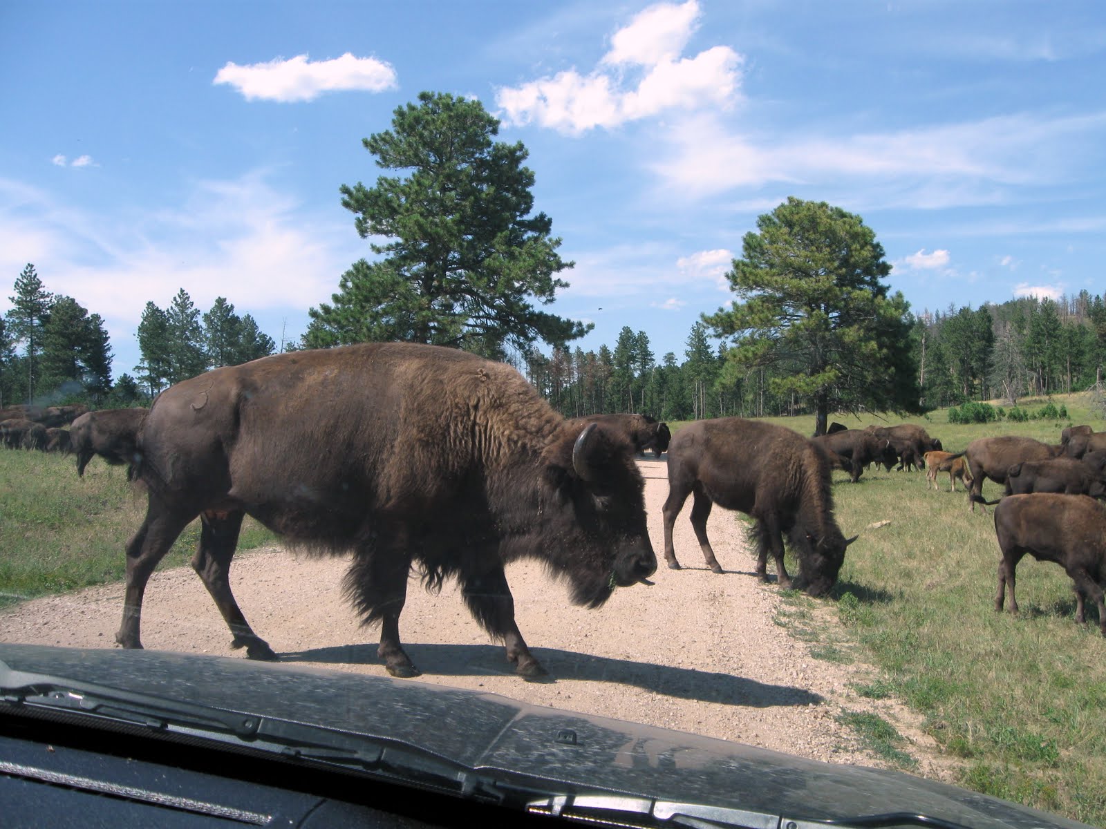
We got the inside tip on where a couple larger herds of bison were located... about 3 or 4 miles down Fisherman Flats Road, a gravel 1.5 lane road with very few straight or flat sections. We came over a rise... and there they were. They were slowly moving, purposefully, it seemed, in one direction and a couple of times they surrounded our car. The ranger estimated each heard in the 200 to 300 range.

During the drive we also found a bunch of pronghorn antelope, a few mule deer, and many "towns" of prairie dogs, which Dar think are the cutest thing going. If she could, she'd adopt a couple of 'em... which would be replacing me since I'd be gone. She also fell in love with this little burro. Women!?

South Dakota Air and Space Museum

The past couple days we've been hanging around the camper and trying to get caught up on journal posts, photos, and other miscellaneous paperwork/computer work. But today, about noon, cabin-fever was setting in and we had to get out and do something.

A good close option was the South Dakota Air and Space Museum, situated at the edge of Ellsworth Air Force Base... about 12 miles from our camp. Since the day was shaping up to be another warm one (we're getting used to it... heat and low humidity = warm days and cool nights), it'd probably be better to be out and about instead of sitting around the bus-house and sweating.

We both have a fondness for aviation. I've always liked airplanes, the thought of flight... the freedom of it... so much so that many years ago I took flying lessons and got my private pilots license. Dar, on the other hand, just has the hots for pilots... any pilots... anyone who flies. Hmmm. Hope my license is still current.


There's no admission to the museum... but a donation is appreciated. Most of their museum pieces are on static display outside... a lot of it the big iron: nice examples of the B-29, a B-52D, an EC-135, a B-1B (I wondered who or what buggered this billion dollar machine up so bad that it's now a museum hulk??), and a myriad of other planes from the post WWII era.


But the highlight of our afternoon was the tour of Ellsworth AFB offered by the museum for only $8 each. What tipped me over to taking the tour was that it included a tour of the training silo for the Minuteman II missile... the only other Minuteman II silo that still exists in addition to the Delta-09 silo we stopped and visited outside of Wall a few days ago.

The catch was that we both had to be screened by base security... and with Dar's checkered past it's likely they'd ask us, politely of course, to get off the bus. They're serious about security these days and aren't going to put up with a couple of troublemakers from Wisconsin if they can avoid it.

Surprisingly, we slipped right past security and onto the base. Our tour guide, named Harry, only had the two of us to deal with... and he could see we were basically harmless anyway. So he drove all over the base, showing us some very modern housing units, recreation and workout facilities, parks, golf course, the BX, the commissary, clubs and bars and gathering spots... why, you wouldn't have to leave the base for much of anything. About 6,000 people work on the base and I was "this close" to signing up.


But then we pulled into the missile silo area. They've kept one transporter/erector truck and one armored security jeep-thing they called the "peacekeeper" for museum purposes. Back when the MM-II was active, groups of these kinds of vehicles would be running around the roads of western South Dakota, moving, loading, and unloading missiles and other equipment from the 150 silos under this base's command.


We were able to descend stairs into the silo... three flights of stair down... about 25 or 30 feet. At that level we walked into the silo and saw the training missile. The MM-II is 60 feet tall and the silo is 90 feet deep. Peering down alongside the missile, especially in such close quarters, it's a shocking long way to the bottom.


It was a good visit... especially after having seen the Delta-09 silo out near Wall. And we always love taking photos of classic aviation machinery.

Tonight, we're hitting the sack early so we can get an early start tomorrow. We hope to visit Wind Cave National Park... and then see what other trouble we can get into.

Stone Faced

Saturday we loaded up the exploration-rig (the toad) and headed into them thar' hills. The Black Hills, that is.

South Dakota's Black Hills are the eroded remnants of a mountainous dome forced upward by volcanic forces many millions of years ago. Despite their eroded nature, they rise 4,000 feet above the surrounding high northern grasslands... like an island in the plains. Harney Peak, at 7,242 feet, is the highest point east of the Rockies and west of the Spanish Pyrenees. The area is about 50 miles by 80 miles and was home to Native Americans for the past 10,000 years.

Heavily forested with Ponderosa Pine, a strong scent of pine is always present when meandering the maze of roads that weave their way through the hills. Due to the ruggedness of the area, wildlife can flourish relatively undisturbed by civilization... although developers are doing their best to turn the place into a vast tourist trap. US16, the road leading from Rapid City to Keystone and the Mt. Rushmore area, is lined with all sorts of glittery touristy "fun" things... Bear Country USA, Reptile Gardens, the Fort Hays Chuckwagon Dinner and Show, Old McDonalds Petting Farm, a Presidential Wax Museum, and Holy Terror Mini Golf are just a few of the places tourists can drop cash and keep the kids happy. I mean... really... who wants to look at rocks and trees when I could be  playing mini golf in the dark with lighted balls? I think that's all I'll say about all that.


The first place we stopped was Mt. Rushmore. I think I wrote the other day that it's been 37 years since Dar and I were here. The facilities are now very new and modern, lining a central arched walkway from the parking garage ($11) to the main viewing plaza. It looks to be mostly constructed of native local granite and, considering the huge number of people it must service, is both functional and elegant. Since it's still summer, and this was a Saturday, the crowds were significant, but not too intrusive.


What can I write that will add to what's been said so many times before about the monument itself... the four Presidents carved into the granite mountain? It's a stunning work of art and also a monument to it's creator, Gutzon Borglum. It was a great day for photography and our two cameras got a real workout.

From Mt. Rushmore we drove down to the Crazy Horse Memorial, something new to us. While it did cost us $20 to get in ($10 each), neither of us had a problem with it considering that most of the expense of finishing this massive work is being paid for by admission fees and donations.


I was a little surprised at the scope of the visitors center and surrounding museum, theater, cultural center, the sculptors preserved home and studio, and the viewing veranda and restaurant. It's all much more than I was expecting. This is clearly a Native American project... driven by the Lakota Sioux. The complete ultimate site plan calls for the addition of a huge museum of the American Indian and the Indian University of North America and Medical Training Center.


The carving itself, begun in 1948 by Korczak Ziolkowski, is immense. The largest carving in the world, it will be 563 feet high and 641 feet long. In comparison, the Mt. Rushmore Memorial, all of it, would fit on the side of Crazy Horse's head. Funded completely by private donations and admission fees, it's a project that will move slowly and could last well over a hundred years.

The story goes that old Korczak, already in his 40s when he started the work in 1948, worked alone for the first 5 years. Every day he had to climb something like 900 stairs to get from his base camp to the top where he was working... lugging air hammers, drills, and tool steel up with him. His first big air compressor (needed to run the equipment) was a tired old Buda compressor that was sitting down at the bottom... the compressed air piped to the top. It had to be hand cranked to get it started. Some days he'd start the old Buda, make sure it was running ok, and start climbing the stairs. About half way up, he'd hear the old Buda chug and kaput to a stop, and he'd have to climb all the way down, restart it, and then back up again to resume the climb to the top. On the worst day, he had to go down and back up again 9 times to tend to the old beast.

Korczak died in 1982 and since then his wife, Ruth, and 7 of their children continue the work. I find myself hoping, but wondering if it will ever actually be completed. I'll never know... nor will anyone alive today. And who will be looking at these massive stone faces a thousand or ten thousand years from now?  And what will they be thinking? Could they be among the most enduring evidence of our culture and civilization after the cockroaches take over?

With a few hours of daylight left, we decided to drive another portion of the Peter Norbeck Scenic Byway. When I wrote earlier about the maze of roads that weave through the Black Hills... this is the epitome. All together, it's a 66 mile double loop of twisting roads, low narrow tunnels, and "pig-tail" bridges that traverse some of the most difficult terrain here. And what a great thing it is... to be able to get to places in the hills where, without the road, you'd have to hike and climb to. The two highlights of the afternoon were portions of the road known as the Needles Highway and the Iron Mountain Road.

The best way to appreciate the Scenic Byway is to go slow. Considering the places you'll stop to walk around and soak in the views, to smell the pine, you might only average 10 miles per hour... maybe less. For example, Needles Highway is only 14 miles long, but took us a little over an hour and a half to complete.

Tunnels. There are 6 tunnels along Needles Highway and Iron Mountain Road. Since the smallest, dimensionally, is only 10' 7" high and 8' 4" wide... it'll be a long time before we take the bus-house on these roads... like never! If you travel from south to north on Iron Mountain Road, the last tunnel perfectly frames Mt. Rushmore, directly in front of you, as you inch through the narrow gap.


Pig-tail bridges. These are bridges that are curved so that they spiral down (or up... depending on your direction) in a tight circle and cross under themselves... a 270 degree or more curve, depending on the geography. We crossed a number of them on Iron Mountain Road.

Shadows were growing long as we finally made it back to Keystone, one of the centers of activity here in the hills. I'd best describe Keystone as the Gatlinburg of South Dakota... enough said.

During our stay in the area, we'll be back into the hills to see more next week. But I think we'll let the weekend crowd have it to themselves on Sunday.

Remember, clicking on any images in this blog will enlarge them. Dar also has many more photos from the day in our online photo collection.