This micro-post is just to say we're doing well and all is OK. Since we paid good money to attend the Escapade rally we're committed to getting the most value possible from it... and that means going to as many seminars, workshops, and social things as we can fit in. But blogging takes a back seat.
Today, Wednesday, I'm planning to learn more about digital photography, ham radio, 12 volt systems in RVs, and will attend an informative session on the coal and oil industry of Northeastern Wyoming. And tonight, from 6 to 9pm, I'm a volunteer golf cart driver... shuttling people back and forth from their rigs to the central event center. I'll be able to knock another thing off my bucket list: working as a cab driver.
We're still planning to hit the road again on Friday, continuing our trek toward Portland.
Devils Tower

The drive took us east about 30 miles to Moorcraft, then north another 30 miles on US-14 to Devils Tower Junction. The Monument's gate is a few miles further and then a short climb to the Visitor Center parking area.

It is an impressive thing. Formed thousands of feet below ground level many millions of years ago when a mass of volcanic lava forced it's way upward and into surrounding sedimentary rocks. The betting is it never made it to the surface... just a relatively small intrusion that didn't have the force necessary to bubble to the surface and grow into a full fledged volcano. It's made up of a rock called phonolite... a mixture of volcanic basalt and feldspar. Phonolite is very hard, much like granite. During the process of cooling the material shrinks and vertical cracks develop, which eventually join other vertical cracks, leaving tall multi-sided columns that give the monolith it's distinctive "clawed" look.
And speaking of "clawed"... many Native Americans consider this place sacred. One of their legends involved the earth saving some young girls from a bear by uplifting this column of rock, with the young girls on top, high into the sky and well above the bears reach. The bear clawed the sides of the tower but was never able to reach the top. Indians commonly refer to the tower as the Bears Den, the Bear's Lair, or Bear's Lodge.
Over eons of time, the surrounding softer rock eroded away leaving the much harder phonolite monolith standing tall above the current surrounding ground level. Rising more than 1,200 feet from the surrounding terrain, it tops out at about 5,100 feet above sea level. The top is more rounded than flat and covers an area of about 1.5 acres.
 |
| Look closely... two climbers on the tower. It's also easy to see the columnar nature of the rock. (click to enlarge) |
No, we didn't get to the top. But others did. We saw dozens of people scaling all sides of the thing and a few people standing at the top. Dar and I are pretty much in agreement on this point: we are not interested in technical rock climbing at all. Many years ago I did "climb" Mt. Hood in Oregon, but it's a relatively easy feat -- not technical at all -- compared to scaling the shear sides of something like Devils Tower.
We stopped and chatted with a ranger in the Visitor Center before heading off on a hike around the Tower... a relatively easy 1.3 mile ashpalt paved path. The tower is surrounded by a boulder field... the "droppings" of millions of years of erosion as the tower sheds large chunks of itself. When I expressed concern about the stability of the rock on the tower and the danger to climbers, the ranger said the last large chunk that fell was 3 years ago... and the Forest Service brought it down intentionally when they deemed it a hazard. It's good to know somebody's looking out for those nutty climbers... and the hikers on the path below.
It was a great day for photography too. Check out our online photo albums of our day at Devils Tower.
On to Wyoming and Escapade
This morning we're hitting the road again on a short 130 mile drive to Gillette, Wyoming and the Escapees Club Escapade. The big event doesn't really start until Sunday afternoon, but we thought we'd get in early and run out to Devils Tower on Saturday. It's also good to relax a little and meet our close-by neighbors before the event and see if I can motivate someone to make me a batch of brownies.
We're not big rally attendees... have only been to two others, both during our first year on the road. And we really don't join many organizations either (wouldn't think of joining an organization that would have me as a member!) But we do like the Escapees Club and thought the location and timing of the Escapade fit right into our plans this year.
We'll be in Gillette until Friday, September 2nd, at which time "travel mode" will become primary and "exploring mode" secondary... since we have only 8 days to make it to Portland. Gillette is about the half way point on our trek from Wisconsin to Oregon/Washington and it took us 26 days to make it that far. So the 8 days to do the second half is pushing it for us. Might be some Wally-docking or Cracker-docking in our near future.
Since leaving Wisconsin we've tried to stay off the Interstate Highway System and have only been on the super-slab 20 miles by the time we hit Rapid City. But from here, westward, we'll be out there among the semi trucks and fast drivers considerably more... and it may take some doing to adjust to the fast and busy pace.
Scratching My Crack
No big explorations to report on either Wednesday or Thursday. We just hung around the RV park working on more of those catch-up things that have been hanging over our heads, as well as a run to the local Cabelas store.
Bus-house windshield. The bus-house is four and a half years old and has 36,000 miles on the odometer. We still have the original windshield, but it has taken a beating during that time. It's a huge hunk of glass (5' tall by 8.5' wide)... one of those one-piece jobs that some years ago motorhome manufacturers started installing for the "un-interrupted panoramic view" out the front end. I guess that's supposed to be a "feature".
The downside to this whole "one-piece" idea comes when you have to replace the dang thing... it's a major job. With the old split windshield, replacement is a relatively easy task. I've watched the replacement of a half windshield in an RV park some time ago. Two guys from the auto glass service can remove the old and install the new in a matter of 20 minutes or so. It's a reasonably sized piece of glass that two guys can handle without special equipment.
But replacement of these huge one-piece buggers is a major job. First off, they're not going to come to you in the RV park and replace it in 20 minutes. No sir (or madam), you'll have to break camp and drive over to their place. Second, not many shops keep something like this in stock and it'll have to be ordered and shipped. And thirdly, the windshield is so big and heavy it takes a crew of people and a fork truck to do the job. Additionally, as these things often go, there's the good chance that something won't be done right, it'll leak somewhere or something, and you'll have to make more trips back to the shop for "get-it-right" follow ups.
And a big downside for me is that after you've gone through all the hassle of getting it replaced... and you've got that big new shiny hunk of glass up front... there's the overpowering fear that it'll get nailed again by a passing gravel truck within the first few miles. So, for me, having a windshield with a few repaired chips and impact craters is better than a new one.
Our windshield has sustained 5 impacts large enough to cause damage over it's four and a half year life. It's interesting to note that I remember the exact spot on the map where each one occurred. The largest divot, one so big the chip repair guy would only do it because I insisted, happened in Montana, on two-lane US-191 between Hilger and Roy about three and a half years ago, when a car traveling the opposite direction kicked up a stone -- a boulder really -- that sounded like a gun-shot when it hit.
Of the first four impacts, two were repaired professionally and two were small enough I took a chance and just let them go. None of the four caused a running crack to develop.
But the fifth one... just a couple weeks ago, was a relatively small hit. I heard it, but could see nothing immediately afterward while driving and thought we lucked out again. However, when we stopped for a break and I took a look from the outside... there was a small chip right on the lower edge on the drivers side... and, curses, there was already a crack, two or three inches long, running northward. Dang! Common knowledge says that once a crack develops, it'll continue to run until it's big and ugly and crosses directly through the driver's line of sight. Replacement is inevitable. Since it happened it has already grown to about 6 inches.
Hmmm. A thought was rolling around in my head. If I could drill a hole at the end of the crack... could that stop it? A little online research indicated that might work... but drilling the hole is problematic because you need a diamond drill bit and steady hand... and there's still a big chance that the whole dang windshield will shatter.
But then I found buried in a user forum somewhere... a comment from an ex-stock car racer that said he had stopped windshield cracks from spreading by taking a simple glass cutter (less than 5 bucks at any hardware store) and scribe a half-inch score in the glass at the furthest point the crack has progressed. The score should be perpendicular to the direction of the running crack. He says he's never had one continue to spread afterward.
So, this morning I did exactly that... I scratched my crack. And we should know pretty quick whether this simple idea works. It may look a little ugly, but if it stops the crack from spreading it will save this chunk of glass for a little while longer. I mean, I've grown very attached to this old scarred windshield.
UPDATE September 2: The idea that you can score the glass ahead of the crack to stop it from spreading has failed. I don't know if I didn't do it right or if my stock car driver source was just making it all up... just don't know. During our recent "big headwind" day, we watched the crack spread despite numerous attempts to score it in this manner.
Bus-house windshield. The bus-house is four and a half years old and has 36,000 miles on the odometer. We still have the original windshield, but it has taken a beating during that time. It's a huge hunk of glass (5' tall by 8.5' wide)... one of those one-piece jobs that some years ago motorhome manufacturers started installing for the "un-interrupted panoramic view" out the front end. I guess that's supposed to be a "feature".
The downside to this whole "one-piece" idea comes when you have to replace the dang thing... it's a major job. With the old split windshield, replacement is a relatively easy task. I've watched the replacement of a half windshield in an RV park some time ago. Two guys from the auto glass service can remove the old and install the new in a matter of 20 minutes or so. It's a reasonably sized piece of glass that two guys can handle without special equipment.
But replacement of these huge one-piece buggers is a major job. First off, they're not going to come to you in the RV park and replace it in 20 minutes. No sir (or madam), you'll have to break camp and drive over to their place. Second, not many shops keep something like this in stock and it'll have to be ordered and shipped. And thirdly, the windshield is so big and heavy it takes a crew of people and a fork truck to do the job. Additionally, as these things often go, there's the good chance that something won't be done right, it'll leak somewhere or something, and you'll have to make more trips back to the shop for "get-it-right" follow ups.
And a big downside for me is that after you've gone through all the hassle of getting it replaced... and you've got that big new shiny hunk of glass up front... there's the overpowering fear that it'll get nailed again by a passing gravel truck within the first few miles. So, for me, having a windshield with a few repaired chips and impact craters is better than a new one.
Our windshield has sustained 5 impacts large enough to cause damage over it's four and a half year life. It's interesting to note that I remember the exact spot on the map where each one occurred. The largest divot, one so big the chip repair guy would only do it because I insisted, happened in Montana, on two-lane US-191 between Hilger and Roy about three and a half years ago, when a car traveling the opposite direction kicked up a stone -- a boulder really -- that sounded like a gun-shot when it hit.
 | |
| a little larger than a quarter. (color and contrast altered to enhance image) |
But the fifth one... just a couple weeks ago, was a relatively small hit. I heard it, but could see nothing immediately afterward while driving and thought we lucked out again. However, when we stopped for a break and I took a look from the outside... there was a small chip right on the lower edge on the drivers side... and, curses, there was already a crack, two or three inches long, running northward. Dang! Common knowledge says that once a crack develops, it'll continue to run until it's big and ugly and crosses directly through the driver's line of sight. Replacement is inevitable. Since it happened it has already grown to about 6 inches.
Hmmm. A thought was rolling around in my head. If I could drill a hole at the end of the crack... could that stop it? A little online research indicated that might work... but drilling the hole is problematic because you need a diamond drill bit and steady hand... and there's still a big chance that the whole dang windshield will shatter.
But then I found buried in a user forum somewhere... a comment from an ex-stock car racer that said he had stopped windshield cracks from spreading by taking a simple glass cutter (less than 5 bucks at any hardware store) and scribe a half-inch score in the glass at the furthest point the crack has progressed. The score should be perpendicular to the direction of the running crack. He says he's never had one continue to spread afterward.
 |
| There's only one crack... the lower one is a reflected image. Note score across path of crack. |
UPDATE September 2: The idea that you can score the glass ahead of the crack to stop it from spreading has failed. I don't know if I didn't do it right or if my stock car driver source was just making it all up... just don't know. During our recent "big headwind" day, we watched the crack spread despite numerous attempts to score it in this manner.
Wind Cave National Park

The drive to Wind Cave is about 55 miles and takes us through the Black Hills towns of Hill City and Custer, both of which impressed us as very neat, affluent, and comfortable. After a few days of running all over this corner of the State we've found the roads in the Black Hills to be nothing less than excellent. The main north-south backbones, US-16 and US-385 on the west side and SD-79 on the east side, appear to be nearly brand new, wide, and smooth. And the various other roads that weave through the area are in good shape too. We really haven't found any that caused us to grimace.
Wind Cave is one of the oldest National Parks in the system... the 7th designated as such... way back in 1903. Named for a hole, a natural entrance, that blew air... it was known to early natives and considered sacred. But in 1881 a couple of cowboys named Bingham stumbled on the hole, heard the sound of blowing air, and when they tried to look down into the hole the rushing air blew their hat off.
For the next few years only a few people ventured a short distance into the hole to look around. But in 1890, a lad named Alvin McDonald, yet a teenager, developed an interest in the cave and started exploring it in earnest. He also gave tours, for a charge, and soon large numbers of people were traipsing through the cave... often chipping off cave decorations and taking them home. Eventually, some influential people became concerned enough to push for government assistance in protecting the cave for future generations. It all came together when Teddy Roosevelt signed the documents in 1903 making Wind Cave a National Park... the first designated to preserve a cave.
We took the "Natural Entrance" tour... an hour and a half tour down the slightly-modified original entrance and along narrow passageways and a few larger "rooms" where the guide could talk to our fairly large group. At the deepest point we were 200 feet beneath the surface. Wind Cave is noted for the cave decoration known as "boxwork", which are thin fins of calcite that formed in cracks in softer limestone... and left behind after the limestone dissolved away. Arrayed in patterns that resemble boxes, they're very rare and only occur in a handful of caves around the world.
 |
| Boxwork |

The feral burros are not native but the descendants of burros used as pack animals in the early days of the parks history. They hang around entrance gates and will stick their noses into any open car window looking for a morsel of food. They've become quite accomplished beggars, and owing to their cuteness, they're a tourist favorite... a big hit with the kids.
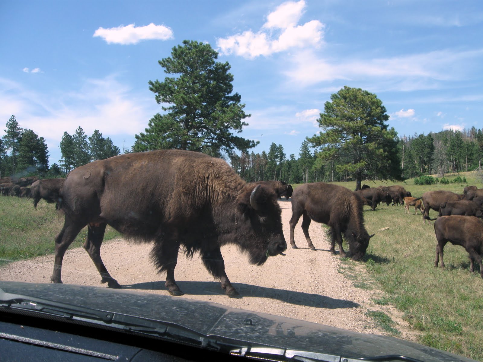
We got the inside tip on where a couple larger herds of bison were located... about 3 or 4 miles down Fisherman Flats Road, a gravel 1.5 lane road with very few straight or flat sections. We came over a rise... and there they were. They were slowly moving, purposefully, it seemed, in one direction and a couple of times they surrounded our car. The ranger estimated each heard in the 200 to 300 range.
During the drive we also found a bunch of pronghorn antelope, a few mule deer, and many "towns" of prairie dogs, which Dar think are the cutest thing going. If she could, she'd adopt a couple of 'em... which would be replacing me since I'd be gone. She also fell in love with this little burro. Women!?

South Dakota Air and Space Museum
The past couple days we've been hanging around the camper and trying to get caught up on journal posts, photos, and other miscellaneous paperwork/computer work. But today, about noon, cabin-fever was setting in and we had to get out and do something.
 A good close option was the South Dakota Air and Space Museum, situated at the edge of Ellsworth Air Force Base... about 12 miles from our camp. Since the day was shaping up to be another warm one (we're getting used to it... heat and low humidity = warm days and cool nights), it'd probably be better to be out and about instead of sitting around the bus-house and sweating.
We both have a fondness for aviation. I've always liked airplanes, the thought of flight... the freedom of it... so much so that many years ago I took flying lessons and got my private pilots license. Dar, on the other hand, just has the hots for pilots... any pilots... anyone who flies. Hmmm. Hope my license is still current.

There's no admission to the museum... but a donation is appreciated. Most of their museum pieces are on static display outside... a lot of it the big iron: nice examples of the B-29, a B-52D, an EC-135, a B-1B (I wondered who or what buggered this billion dollar machine up so bad that it's now a museum hulk??), and a myriad of other planes from the post WWII era.

But the highlight of our afternoon was the tour of Ellsworth AFB offered by the museum for only $8 each. What tipped me over to taking the tour was that it included a tour of the training silo for the Minuteman II missile... the only other Minuteman II silo that still exists in addition to the Delta-09 silo we stopped and visited outside of Wall a few days ago.
The catch was that we both had to be screened by base security... and with Dar's checkered past it's likely they'd ask us, politely of course, to get off the bus. They're serious about security these days and aren't going to put up with a couple of troublemakers from Wisconsin if they can avoid it.
Surprisingly, we slipped right past security and onto the base. Our tour guide, named Harry, only had the two of us to deal with... and he could see we were basically harmless anyway. So he drove all over the base, showing us some very modern housing units, recreation and workout facilities, parks, golf course, the BX, the commissary, clubs and bars and gathering spots... why, you wouldn't have to leave the base for much of anything. About 6,000 people work on the base and I was "this close" to signing up.

But then we pulled into the missile silo area. They've kept one transporter/erector truck and one armored security jeep-thing they called the "peacekeeper" for museum purposes. Back when the MM-II was active, groups of these kinds of vehicles would be running around the roads of western South Dakota, moving, loading, and unloading missiles and other equipment from the 150 silos under this base's command.

We were able to descend stairs into the silo... three flights of stair down... about 25 or 30 feet. At that level we walked into the silo and saw the training missile. The MM-II is 60 feet tall and the silo is 90 feet deep. Peering down alongside the missile, especially in such close quarters, it's a shocking long way to the bottom.

It was a good visit... especially after having seen the Delta-09 silo out near Wall. And we always love taking photos of classic aviation machinery.
Tonight, we're hitting the sack early so we can get an early start tomorrow. We hope to visit Wind Cave National Park... and then see what other trouble we can get into.
Stone Faced

South Dakota's Black Hills are the eroded remnants of a mountainous dome forced upward by volcanic forces many millions of years ago. Despite their eroded nature, they rise 4,000 feet above the surrounding high northern grasslands... like an island in the plains. Harney Peak, at 7,242 feet, is the highest point east of the Rockies and west of the Spanish Pyrenees. The area is about 50 miles by 80 miles and was home to Native Americans for the past 10,000 years.
Heavily forested with Ponderosa Pine, a strong scent of pine is always present when meandering the maze of roads that weave their way through the hills. Due to the ruggedness of the area, wildlife can flourish relatively undisturbed by civilization... although developers are doing their best to turn the place into a vast tourist trap. US16, the road leading from Rapid City to Keystone and the Mt. Rushmore area, is lined with all sorts of glittery touristy "fun" things... Bear Country USA, Reptile Gardens, the Fort Hays Chuckwagon Dinner and Show, Old McDonalds Petting Farm, a Presidential Wax Museum, and Holy Terror Mini Golf are just a few of the places tourists can drop cash and keep the kids happy. I mean... really... who wants to look at rocks and trees when I could be playing mini golf in the dark with lighted balls? I think that's all I'll say about all that.

The first place we stopped was Mt. Rushmore. I think I wrote the other day that it's been 37 years since Dar and I were here. The facilities are now very new and modern, lining a central arched walkway from the parking garage ($11) to the main viewing plaza. It looks to be mostly constructed of native local granite and, considering the huge number of people it must service, is both functional and elegant. Since it's still summer, and this was a Saturday, the crowds were significant, but not too intrusive.

What can I write that will add to what's been said so many times before about the monument itself... the four Presidents carved into the granite mountain? It's a stunning work of art and also a monument to it's creator, Gutzon Borglum. It was a great day for photography and our two cameras got a real workout.
From Mt. Rushmore we drove down to the Crazy Horse Memorial, something new to us. While it did cost us $20 to get in ($10 each), neither of us had a problem with it considering that most of the expense of finishing this massive work is being paid for by admission fees and donations.

I was a little surprised at the scope of the visitors center and surrounding museum, theater, cultural center, the sculptors preserved home and studio, and the viewing veranda and restaurant. It's all much more than I was expecting. This is clearly a Native American project... driven by the Lakota Sioux. The complete ultimate site plan calls for the addition of a huge museum of the American Indian and the Indian University of North America and Medical Training Center.

The carving itself, begun in 1948 by Korczak Ziolkowski, is immense. The largest carving in the world, it will be 563 feet high and 641 feet long. In comparison, the Mt. Rushmore Memorial, all of it, would fit on the side of Crazy Horse's head. Funded completely by private donations and admission fees, it's a project that will move slowly and could last well over a hundred years.
The story goes that old Korczak, already in his 40s when he started the work in 1948, worked alone for the first 5 years. Every day he had to climb something like 900 stairs to get from his base camp to the top where he was working... lugging air hammers, drills, and tool steel up with him. His first big air compressor (needed to run the equipment) was a tired old Buda compressor that was sitting down at the bottom... the compressed air piped to the top. It had to be hand cranked to get it started. Some days he'd start the old Buda, make sure it was running ok, and start climbing the stairs. About half way up, he'd hear the old Buda chug and kaput to a stop, and he'd have to climb all the way down, restart it, and then back up again to resume the climb to the top. On the worst day, he had to go down and back up again 9 times to tend to the old beast.
Korczak died in 1982 and since then his wife, Ruth, and 7 of their children continue the work. I find myself hoping, but wondering if it will ever actually be completed. I'll never know... nor will anyone alive today. And who will be looking at these massive stone faces a thousand or ten thousand years from now? And what will they be thinking? Could they be among the most enduring evidence of our culture and civilization after the cockroaches take over?

The best way to appreciate the Scenic Byway is to go slow. Considering the places you'll stop to walk around and soak in the views, to smell the pine, you might only average 10 miles per hour... maybe less. For example, Needles Highway is only 14 miles long, but took us a little over an hour and a half to complete.
Tunnels. There are 6 tunnels along Needles Highway and Iron Mountain Road. Since the smallest, dimensionally, is only 10' 7" high and 8' 4" wide... it'll be a long time before we take the bus-house on these roads... like never! If you travel from south to north on Iron Mountain Road, the last tunnel perfectly frames Mt. Rushmore, directly in front of you, as you inch through the narrow gap.

Pig-tail bridges. These are bridges that are curved so that they spiral down (or up... depending on your direction) in a tight circle and cross under themselves... a 270 degree or more curve, depending on the geography. We crossed a number of them on Iron Mountain Road.
Shadows were growing long as we finally made it back to Keystone, one of the centers of activity here in the hills. I'd best describe Keystone as the Gatlinburg of South Dakota... enough said.
During our stay in the area, we'll be back into the hills to see more next week. But I think we'll let the weekend crowd have it to themselves on Sunday.
Remember, clicking on any images in this blog will enlarge them. Dar also has many more photos from the day in our online photo collection.
Scenic For Sale

We have in our acquaintance a couple of good souls who have been toying with the idea of buying a piece of property and starting their own country. They, like a lot of us, are getting close to giving up on the good ol' USA... feeling helpless, powerless, and represented by idiots. They long for rationality, reasonableness, and equal opportunity... things many of us feel slipping away. I know... there'd be a lot of hurdles to making this a reality and the idea has about as much chance as a snowball in South Texas. But it's certainly a good thought exercise and a lot of fun to ponder. We'd even discussed, in jest, whether this "town for sale" could fit into the plans.

Well, what'dya know... our drive between the Badlands and the Rapid City area on SD-44 took us right by Scenic. That's right... we could stop in and check out the town for our friends... and maybe get the inside track on a quick sale.

There are three exits off SD-44 for Scenic. I slowed as we neared the first and found a badly rutted gravel/dirt road. Proceeding to exit two... same thing. But exit three was the charm... a hard surfaced road. So in we went and found an acceptable parking spot right in front of the jail.

There's not much to Scenic but what's there has possibilities... Dar thinks real possibilities! The first place I ended up was in jail. (memories of my past?? or just bad dreams??)
All the essentials are there... a post office, a saloon, a diner, a hotel/hostel/bunkhouse, and a gas station/convenience store. I mean, what else would you really need in a small basic town?

Pondering this opportunity a little more, I wondered which way this ownership thing really goes? Does the person own the town... or does the town own the person? With many, if not most, ownership situations -- regardless of what it is that's being owned -- the thing really owns the person. With ownership comes responsibilities including upkeep, maintenance, repairs, taxes, liabilities, and storage... and probably more burdens I can't think of right now. I, for one, am sure I'm not ready for all this... especially on the scale of a whole town.
But alas, all the dreaming and thought games came crashing to an end today when I found that the town now has a buyer and the sale is supposed to close this next week. For now, at least, it appears Scenic is off the table.
The Badlands and the Doomsday Machine

At first glance it all looks so desolate and lifeless. And it's true... these are tough conditions for life. But on closer examination life is everywhere. Small plants shoving aside a shard of crust and poking up through the soft rock... a little pine tree clinging to a crevice on a vertical slope... burrowing animals. When viewed carefully and up-close, it's rewarding to find these small footholds of life... and to marvel at their adaptations to this harsh environment.

Thursday, we drove and explored the loop road through the middle of the park. Stopping at almost every pull-out and overlook, soaking in an experience that is so different from your run-of-the-mill walk in nature. The way these layers of material were laid down over the eons of time provided perfect conditions for preserving evidence of early life, plants and animals that have long since gone extinct but are preserved here as fossils in soft eroding stone. Both paleontologists and vacationers (even kids) have found fossils freshly uncovered by the process of erosion.

The day was slightly hazy and thus not all that great for photography. But we did our best and our photos are mostly for the record and probably won't be in a fine art gallery near you any time soon. No delusions there.
As we exited the park through the north gate, a late lunch sounded good so we checked the map for anything nearby. Hmmm. The only thing that popped up was the town of Wall. Yes, that Wall! Thinking back, we believe it was 1974 when we were here last... 37 years ago. (Yikes... time screams by!) We stopped at Wall Drug at that time and about all I remember was seeing shelves full of jackalopes. (if you don't know... google it)

Well I'm here to testify that Wall Drug has been taking steroids. I really don't remember much from 37 years ago, but it certainly wasn't the full city square block sized retail monstrosity that we witnessed that day. I had no idea. Free parking surrounded for blocks around. Cars and motorcycles and RVs and trucks and people were everywhere on this Thursday afternoon. Clearly, the old formula of advertising free ice water alongside the nearby hot dusty roads must still be working. Wow.
Yes, we did find our way to the cafe inside, had a quick sandwich and requisite free cup of ice water... and then left.
From Wall we drove I-90 eastward. At exit 116 we pulled off and took a gravel road to the right, which wound around to a nondescript and unsigned fenced in area about the size of a football field. There was very little parking and the gate was slightly ajar -- just enough for a person to slip in. No one was around. A pamphlet holder on the gate contained an info-sheet that diagramed and described what we were seeing. We slipped in.

On one end of the area was a small flat concrete thing covered with glass panels. We approached and looked in... and down... at a Minuteman II missile in it's silo. This was Delta-09, the only preserved and open to the public Minuteman II silo that remains of the 150 that were strewn around just South Dakota during the cold war. There were hundreds more in other surrounding states. After the signing of the START treaty in 1991, 149 of the South Dakota silos were "imploded" -- deactivated and destroyed. This was the only one preserved, according to the info-sheet, "to tell the story of the Minuteman's role in deterring a conventional war and preserving the peace." There was no going down into the silo as it's sealed. All we could do was look down at the sleek machine it contained and wonder... were they right? Did these devices preserve peace by assuring total annihilation? Where we looking at an element of a doomsday machine? You've also gotta wonder, now that technology has advanced another 50 years from these 1960-ish gizmos, what threats and challenges are in our future?

Down the road a few more miles, at exit 131 was the Minuteman Missile National Historic Site Visitors Center -- not much more than a couple portable buildings next to a Conoco gas station. There a visitor can sign up for a tour of the one preserved underground launch control facility that's a part of the historic site. They were sold out for the day, but my interest was marginal anyway.
From there it's just a few miles south to the Northeast gate of the Badlands National Park and back to our campsite at Cedar Pass.
Dar has many more photos from our day in our online photo collection. Check 'em out if you'd like.
Whippersnappers and Fossils
What he said:
"Hey Mister... this is a pretty intensive hike. It goes straight up that wall to the top. A few miles down the road there's another trail that'll get you to the same place... but it's much more level and a lot easier."
What I think I said:
"Oh, (pause)... OK... thanks for the tip"
What I heard:
"Hey, grandpa... I don't think this is the hike for old fossils like you. It's for young fit hardbodies that workout and exercise every day... people like me. Why don't you elderly folks drive a little further down the road where there's another much easier trail. Why, I think you can even use a walker or wheelchair on it."
What I wanted to say:
"Hey you smartass whippersnapper... how old and crippled do you think we are? Why don't you come over here and grandma will introduce you to the side of her walking stick."
We were at the Saddle Pass trail-head in the Badlands National Park and intending to take the short hike to the top of the "wall"... for a look-around. Could probably get some great pictures from up there on a bright morning like this. We were gearing-up for the walk... hiking boots, Dar's hiking poles, water... and had exchanged pleasantries with the young fellow who parked next to us. After he walked a ways up the trail, he turned and initiated the exchanged recounted above.
With that, he hopped up the hill and out of site. We shook off this boost of confidence and agreed to proceed, to see what we'd encounter. The Park Service has this trail classified as "strenuous"... but we've also been of the opinion, based on many other hikes on public lands, that they usually exaggerate the rating a little in order to be on the safe side... so as not to lure people into hikes they shouldn't be doing. We've done some pretty severe hikes in the past and we really didn't think this one would exceed our capabilities.
So up we went... scrambling in a few steep areas... but a very do-able hike for fit old fogies like us. In short order we were standing at the top... looking for any signs of our friend...
"Hey Kid... check out grandma and grandpa! We made it and didn't even break a serious sweat.
"Hey Mister... this is a pretty intensive hike. It goes straight up that wall to the top. A few miles down the road there's another trail that'll get you to the same place... but it's much more level and a lot easier."
What I think I said:
"Oh, (pause)... OK... thanks for the tip"
What I heard:
"Hey, grandpa... I don't think this is the hike for old fossils like you. It's for young fit hardbodies that workout and exercise every day... people like me. Why don't you elderly folks drive a little further down the road where there's another much easier trail. Why, I think you can even use a walker or wheelchair on it."
What I wanted to say:
"Hey you smartass whippersnapper... how old and crippled do you think we are? Why don't you come over here and grandma will introduce you to the side of her walking stick."
We were at the Saddle Pass trail-head in the Badlands National Park and intending to take the short hike to the top of the "wall"... for a look-around. Could probably get some great pictures from up there on a bright morning like this. We were gearing-up for the walk... hiking boots, Dar's hiking poles, water... and had exchanged pleasantries with the young fellow who parked next to us. After he walked a ways up the trail, he turned and initiated the exchanged recounted above.
 |
| Grandma Fossil working a steep section of trail. |
With that, he hopped up the hill and out of site. We shook off this boost of confidence and agreed to proceed, to see what we'd encounter. The Park Service has this trail classified as "strenuous"... but we've also been of the opinion, based on many other hikes on public lands, that they usually exaggerate the rating a little in order to be on the safe side... so as not to lure people into hikes they shouldn't be doing. We've done some pretty severe hikes in the past and we really didn't think this one would exceed our capabilities.
So up we went... scrambling in a few steep areas... but a very do-able hike for fit old fogies like us. In short order we were standing at the top... looking for any signs of our friend...
"Hey Kid... check out grandma and grandpa! We made it and didn't even break a serious sweat.
 |
| Fossils on top. |
A Good Drive to the Badlands
We got an early start out of Cottonwood COE near Yankton on Wednesday morning. The day was bright and quiet... and what little wind we experienced during the day gave us a push to some degree. We decided to once again shun the Interstate Highway System and stick to mostly 2-lane US and State highways. Our route took us over the Fort Randall Dam... the next higher dam from Gavins Point on the Missouri. From there, we clawed through the heart of southern South Dakota, through farm country and Indian Reservations and, somewhere, oh, maybe somewhere west of Winner, South Dakota, crossed from the "Midwest" to the "West". I notice this every time we make the trip west... there's a point, OK, maybe an area... where you cross from the Midwest with it's farm fields of corn and soybeans, it's dairy cows, it's county fairs, it's smaller farms and fields... to the West with it's wheat fields and grazing land, horses, steers, it's rodeos, and it's wide open spaces. At the same time there's a noticeable change in the humidity... and the sky seems bigger. Hard to explain, but bigger. We crossed into the West today.

Our objective was to make it to the area of the Badlands National Park -- about 280 miles for the day. There's a basic campground of sorts in the park and, since we're only going to stay for maybe two nights, we'd thought we'd make that our primary target. . There were a couple alternates in the small town of Interior just to the south of the Badlands Visitors Center... so even if "plan A" didn't work out, there were options.

Well, we arrived about 3pm and drove through the Badlands NP campground with it's funny arrangement of one-way circular roads and "wide spots" that are the designated campsites. Some have power and some don't. We found one of the last sites with electric, pulled in, and found we could make it work fine for two nights. Even though it had power (50 amp to my surprise) it was a tad "pricey" at $28 per night. But we're parked in the National Park, with gorgeous vistas of colorful peaks and rock formations and stunning sunsets and awesome sunrises. The only thing, even slightly negative to write about, is the heat. In this higher and dryer climate, the sun can really get to work and heat things up when it's out. After we arrived the air temp rose to well into the '90's... which drives the interior of the bus-house even higher. Suddenly, I'm real glad we've got that 50amp pedistal right over there, and we've got both air conditioners running full blast just to keep us under three digits.
Then, as soon as the sun gets low in the sky... about a half-hour before sunset... the air starts to cool noticably and the A/C is switched off. Dry air, without the power of the sun, cools quickly. It might sound strange, but by shortly after sunset there's a coolness in the air that can send some people looking for more clothing. That's the West... especially, the high-country West.

After setting up we headed over to the Visitors Center and picked up some history and information to make our exploration the following day productive. Then, as tired as we were after a long day of traveling, we opted to have dinner at the Cafe in the Lodge. We split a ceasar salad and a taco on flat bread. It was acceptable but certainly not high-class dining. Some people live to eat... most of the time we eat to live.
More exploring tomorrow!
Camping with High Water and Mayflies

And speaking of high water, the COE is still "spilling" 150,000 cubic feet of Missouri River water through the Gavins Point spillway. Although the crest of the 2011 flood occurred some weeks ago, it's August and they've got to start lowering the reservoirs to prepare for next years runoff. It's impressive indeed... to stand next to the spillway and watch all that water violently churning as it speeds downriver. We made a short video (click here) for anyone who'd like to see it.

There are 6 dams on the main stem of the Upper Missouri River built to minimize flooding, produce electric power, and provide recreation opportunities for surrounding residents. This is the fourth one we've camped at (Fort Peck, Garrison, Oahe, and now Gavins Point).
We had decided not to come over here for last weekend... concerned after checking online that the campgrounds were full. Indeed, the internet reservation system indicated as much, and a phone call to the COE confirmed it... at least for the one campground they operate. All together, State and Federal, South Dakota side and Nebraska side, there must be almost 1000 campsites around the dam and lake... it's a very popular vacation spot. But if they were as booked-up as they seemed to indicate, the stream of campers leaving yesterday morning must have been almost as impressive as the water coming over the spillway. At least two State of South Dakota operated campgrounds we drove through after setting up camp... both very nice and would easily accommodate the big ol' bus-house... were virtually empty by 5pm.

I was also a little put off by the thought of crowds (a thousand campsites could mean a thousand campfires, thousands of kids, dogs, drinkers, cars, bikes, late parties, and more). Since we weren't here over the weekend, I can't testify to any of that. But today, Monday, it's peaceful and very agreeable.

Our trip over from Algona yesterday was an enjoyable 200 mile jaunt on mostly two lane roads. Some of those roads were rough, some were narrow, and we did get jostled around some... but we managed and didn't break anything that we're aware of (although, as of this writing, we haven't opened up every cabinet yet... so something could still jump out and crash to the floor).
We think we'll be here until Wednesday before heading toward the setting sun once again.
Oh, and for the record, I have to mention the surprise visit we had the other day, Friday I think it was (we were still in Algona), from my sister Jan and brother-in-law Dave. We had known they were heading to Sioux Falls for their anniversary weekend getaway but had no idea they'd be coming right down US-18 and right through Algona. We were standing in the grocery store at the intersection of 18 and 169 when our phone rang... it was Jan and they were looking for us. Well, by the time we finished checking out they were in the parking lot. Nice surprise! They joined us for a short visit out at camp before continuing on to SF. Thanks you guys for stopping in and brightening our day. We don't get many visitors from our home town when we're out exploring... ya know. Happy Anniversary to you two. And thanks for the growler.
Hobos and Tramps
Since we were this close we felt we had to go. I mean, it's only held one time each year, on the second weekend in August, and this year, 2011, this is the weekend.
 I may have heard something about it... on PBS or NPR... years ago. But really... who's going to go far out of their way to attend something called the National Hobo Convention? Com'on... I'm not a hobo. Am I? Sure, I'm a wandering itinerant, live "on the road" fulltime, and I do look for handouts along the way... I don't have a permanent home in a fixed location... and the only reason I'd consider "working" is if or when my money runs out. Hmmm. Maybe I have more in common with this hobo-thing than I thought.
So, since we're so close, just 27 miles away, and with nothing else to do on a cool cloudy Saturday, I guess we have a responsibility of sorts... to ourselves... to find out what we have in common with hobos and to learn a little more about what this lifestyle is all about. So off we went.
Like me, you're probably thinking that hobos were a sub-culture that had long ago died out. I was also tempted to believe this convention thing was mostly a put-on... a reenactment of sorts... like those people who dress up in civil war garb and reenact civil war battles on weekends. But, like me, you'd be wrong! Real, live, in the flesh, hobos still travel the rails and live a nomadic existence on the road, and a goodly group of them show up every year in Britt, Iowa for their annual convention. Color me red! Yes, the hobo culture still exists and, thanks to a couple sharp-minded civic promoters from the town of Britt, Iowa... way back in 1900... they have convened in Britt each year since. It's almost as if Britt could be called the hobo capital of the world.
We arrived shortly after 10am and the parade had already started. Those who procrastinate and are always late love parades... because we've learned that even though the parade has already started and that we're LATE, you can still see the whole dang thing by finding a seat near the end of the parade route. We sat with a group of locals under a big walnut tree and chatted for almost half an hour before the START of the parade finally, at long last, made it's way to us. And there, amongst the fire trucks, the wagons full of high school classes of old (61. 66, 81, etc), the classic cars and tractors (remember, this is farm country)... there... on a wagon full of real life hobos... on a raised seat way up top... was the Hobo King and the Hobo Queen from last years convention. This was their final spin around Britt before they surrender their exalted positions to a new couple who will be elected this very afternoon.

Hobos are all dubbed with monikers... nicknames that are a little more descriptive of the person. For example, some famous Hobos from the past were Iowa Blackie, Fishbones, Hobo Lump, Bo Grump, and Cinders.

OK, so what is a hobo... officially. Well, this is it: Hobos are workers who wander... an itinerant or migratory worker.
I'm growing a little concerned at this point. Since Dar has a special skill (nursing) and she does work (for a few months the past two years)... and let's see... she is certainly migratory (summer North... winter South)... she fits right into the definition of a hobo. As a mater of fact, she fits in so well she might be eligible for Hobo Queen some day. However, with no special skill and since I'm certainly only going to work if I'm forced to... Oh Woe!... it looks like I'm a tramp! May have to change the title of the blog to "Hobo and the Tramp".
A couple more hobo terms: a "bridger" is a hobo that has ridden the rails behind both steam and diesel locomotives. There are very few "bridgers" left. And a "rubber-tramp" is a hobo (or tramp) that has forsaken the rails for rubber tires... usually on an old car, van, or RV. (Wait a minute... now that's hitting a little too close to home!)
Britt pulls out all the stops for this four day event. Saturday is the culmination, the high-point, of the week... with the parade, the election and coronation of the new Hobo King and Hobo Queen, and the noon Mulligan Stew feast, which is free (what did I say earlier about handouts?) and for which people line up for a city block or more to take as much of it as they can carry in whatever container they can bring. Almost everyone in line has a large pot, dutch oven, or recycled ice cream bucket in which to lug home the treasured Hobo Mulligan Stew. The good people of Britt make hundreds of gallons of the stuff, mixed and heated in a dozen or so large pots made from 55 gallon drums... and they dish it out in any quantity to anybody in line.
A mish-mosh of potatoes, meat, carrots, rice, vegetables, celery (don't know what celery is, but it's not a vegetable!)... really, whatever you have... Mulligan Stew is a traditional food of the road. As the hobos would gather and camp for the night, they'd contribute whatever "makins" they might have had, threw it all in one pot, and boiled it until tender and edible. That's Mulligan Stew! After the crowd ebbed and the line shrank, we got our free bowl and slurped it up. It's really comfort food for the vagabond.
We sat in the bleachers and listened to various hobos get up to say what was on their mind. A few have been on the road for 20 or 30 years. Some have homes, but still travel much of the year. Some recited poetry they had written, some sang songs. Then the electoral process began with each candidate for Hobo Queen addressing the crowd. After each had spoken, their names were called individually and the loudest crowd response indicated the winner. Same with the King. The now certified results for 2011... the Queen is Minneapolis Jewel... and the King is Uncle Freddie, who is one of the last remaining bridgers.
Deciding not to stay for the toilet bowl races, we walked back to the car and toured "The Jungle"... the hobo camp set up alongside the railroad tracks, and the Evergreen Cemetery (in keeping with the "cemetery theme of this week") where there's a special section way out back for hobo graves and memorials.
All kidding aside for one lousy paragraph... the event made me more aware of this real but dying subculture... that there are more similarities to us, as fulltimer RVers, than differences... and that we may not be far away from a resurgence of hobo-ism, of desperate people having no other choice but to live on the road, if we don't get this economy and our politics straightened out soon.
How much fun can a person have in one day?
Dar will have more photos uploaded in the next day or two, so check them out if you have a chance. And tomorrow, Sunday, we're off again. Westward Ho!

So, since we're so close, just 27 miles away, and with nothing else to do on a cool cloudy Saturday, I guess we have a responsibility of sorts... to ourselves... to find out what we have in common with hobos and to learn a little more about what this lifestyle is all about. So off we went.
Like me, you're probably thinking that hobos were a sub-culture that had long ago died out. I was also tempted to believe this convention thing was mostly a put-on... a reenactment of sorts... like those people who dress up in civil war garb and reenact civil war battles on weekends. But, like me, you'd be wrong! Real, live, in the flesh, hobos still travel the rails and live a nomadic existence on the road, and a goodly group of them show up every year in Britt, Iowa for their annual convention. Color me red! Yes, the hobo culture still exists and, thanks to a couple sharp-minded civic promoters from the town of Britt, Iowa... way back in 1900... they have convened in Britt each year since. It's almost as if Britt could be called the hobo capital of the world.
We arrived shortly after 10am and the parade had already started. Those who procrastinate and are always late love parades... because we've learned that even though the parade has already started and that we're LATE, you can still see the whole dang thing by finding a seat near the end of the parade route. We sat with a group of locals under a big walnut tree and chatted for almost half an hour before the START of the parade finally, at long last, made it's way to us. And there, amongst the fire trucks, the wagons full of high school classes of old (61. 66, 81, etc), the classic cars and tractors (remember, this is farm country)... there... on a wagon full of real life hobos... on a raised seat way up top... was the Hobo King and the Hobo Queen from last years convention. This was their final spin around Britt before they surrender their exalted positions to a new couple who will be elected this very afternoon.

Hobos are all dubbed with monikers... nicknames that are a little more descriptive of the person. For example, some famous Hobos from the past were Iowa Blackie, Fishbones, Hobo Lump, Bo Grump, and Cinders.

OK, so what is a hobo... officially. Well, this is it: Hobos are workers who wander... an itinerant or migratory worker.
"The hobo is a migratory worker, some with a special skill or trade, others ready to work at any task, but always willing to work to make his way."Closely associated, but distinctly apart from hobos are tramps and bums. Tramps are those who wander and work only when forced to and bums are so lazy they will neither work nor wander. In other words, hobos are the creme-de-la-creme of all wanderers, vagabonds, and nomads.
I'm growing a little concerned at this point. Since Dar has a special skill (nursing) and she does work (for a few months the past two years)... and let's see... she is certainly migratory (summer North... winter South)... she fits right into the definition of a hobo. As a mater of fact, she fits in so well she might be eligible for Hobo Queen some day. However, with no special skill and since I'm certainly only going to work if I'm forced to... Oh Woe!... it looks like I'm a tramp! May have to change the title of the blog to "Hobo and the Tramp".
A couple more hobo terms: a "bridger" is a hobo that has ridden the rails behind both steam and diesel locomotives. There are very few "bridgers" left. And a "rubber-tramp" is a hobo (or tramp) that has forsaken the rails for rubber tires... usually on an old car, van, or RV. (Wait a minute... now that's hitting a little too close to home!)
Britt pulls out all the stops for this four day event. Saturday is the culmination, the high-point, of the week... with the parade, the election and coronation of the new Hobo King and Hobo Queen, and the noon Mulligan Stew feast, which is free (what did I say earlier about handouts?) and for which people line up for a city block or more to take as much of it as they can carry in whatever container they can bring. Almost everyone in line has a large pot, dutch oven, or recycled ice cream bucket in which to lug home the treasured Hobo Mulligan Stew. The good people of Britt make hundreds of gallons of the stuff, mixed and heated in a dozen or so large pots made from 55 gallon drums... and they dish it out in any quantity to anybody in line.
 |
| The hobo mulligan stew serving area |
We sat in the bleachers and listened to various hobos get up to say what was on their mind. A few have been on the road for 20 or 30 years. Some have homes, but still travel much of the year. Some recited poetry they had written, some sang songs. Then the electoral process began with each candidate for Hobo Queen addressing the crowd. After each had spoken, their names were called individually and the loudest crowd response indicated the winner. Same with the King. The now certified results for 2011... the Queen is Minneapolis Jewel... and the King is Uncle Freddie, who is one of the last remaining bridgers.
 |
| Hobo King and Queen Uncle Freddie (left) and Minneapolis Jewel (right) |
All kidding aside for one lousy paragraph... the event made me more aware of this real but dying subculture... that there are more similarities to us, as fulltimer RVers, than differences... and that we may not be far away from a resurgence of hobo-ism, of desperate people having no other choice but to live on the road, if we don't get this economy and our politics straightened out soon.
How much fun can a person have in one day?
Dar will have more photos uploaded in the next day or two, so check them out if you have a chance. And tomorrow, Sunday, we're off again. Westward Ho!
Rockin' Around Kossuth County
Wednesday, yesterday, was originally the day we had planned to continue westward. But after much research and some phone calls to the State and Federal campgrounds around Gavins Point Dam on the Missouri River near Yankton South Dakota... where we'd planned to stay through this coming weekend, it became apparent that, 1) every campsite that could be reserved was reserved for the upcoming weekend, 2) the few walk-in sites they have were currently full, and 3) even if we took a chance and snagged a cancellation or possible walk-in site it was going to be busy and congested. Hmmm. This is all to be understood... I mean, it's summer, August! Probably the busiest month of the year for family camping vacations. Add to that the big lake behind the dam, and all the boating and other water sports activities... and all the population that lives close by -- Sioux Falls, Sioux City, Omaha... Well, we'll just make adjustments to the trip plan and chill out.
So, our "bird-in-the-hand" campsite here at Smith Lake County Park was beginning to look like the best alternative for the weekend. I mean, we're established here, we like it, and are still finding new things to do. We're still hoping to sample the Gavins Point Dam area but will do so no sooner than Sunday... after some of the crowd abates.
In the meantime, we did some local exploring yesterday. First on the agenda was the small well kept Union Cemetery a few miles out in the country northwest of our camp. A neighbor of ours here at Smith Lake turned us onto the historic significance of it. There's a story of mystery and folklore that's associated with it and I'll include a link here if someone wants to read the story, which is interesting but too long for this Journal.

The next place on the tour was the village of Lone Rock, Iowa (pop. 100+). The story goes that a large rock laying out on the prairie became a landmark of sorts to early pioneers and settlers traveling through this area. It came to be called Lone Rock, and due to the trails leading to and from the monolith a couple settlers established a small crossroads community there in the middle 1800s. A few years later, about 1899, when the route of a new rail line bypassed the now larger town about 3 miles to the south, the good residents decided to move the entire town (everything except the rock itself) to the railroad. And that's the way things stayed until about 1970 when someone decided it would be a good idea to liberate the rock from it's lonely resting spot 3 miles to the north, out in the middle of nowhere... and finally reunite the rock with it's namesake community. Well, the estimated 175 ton rock didn't come easily and eventually had to blasted (with dynamite) into smaller and more easily handled pieces. Despite trying to reassemble the pieces into something approximating the original... trying to cable the chunks together... trying to put Humpty Dumpty back together again... they ended up with a broken rock.

Some say the spirit of the town was broken along with the lone rock that day... the day it was blown apart. Others think it's just coincidence the town's decline seemed to accelerate after that. And still others see a moral to this story: the act of possessing something can destroy it.
And finally we drove to West Bend, Iowa and to the Grotto of the Redemption. Reputed to be the largest grotto in the world, it was the conception of Father Paul Dobberstein, a Catholic priest, who started building the grotto in 1912 and made it his life's work until he died in 1954. Others assisted Father Dobberstein and continued his dream even after his death. And yet today there's a dedicated group of people that continue to maintain and operate the grotto, and tend to the estimated 100,000 people that visit annually.

This is just something you don't see anywhere else. As much as anything, it's the scale of the work that impresses the most. The amount of effort to collect minerals from all 50 states and most of the countries of the world, to categorize and store the specimens, to plan the design, and to painstakingly apply each piece, one by one...millions of pieces over so many years... into this!

What an amazing accomplishment. We'd categorize this one as a "must see". And Dar has more photos of the day in our online photo albums... just click on the photo link above and check them out.
So, our "bird-in-the-hand" campsite here at Smith Lake County Park was beginning to look like the best alternative for the weekend. I mean, we're established here, we like it, and are still finding new things to do. We're still hoping to sample the Gavins Point Dam area but will do so no sooner than Sunday... after some of the crowd abates.
In the meantime, we did some local exploring yesterday. First on the agenda was the small well kept Union Cemetery a few miles out in the country northwest of our camp. A neighbor of ours here at Smith Lake turned us onto the historic significance of it. There's a story of mystery and folklore that's associated with it and I'll include a link here if someone wants to read the story, which is interesting but too long for this Journal.


Some say the spirit of the town was broken along with the lone rock that day... the day it was blown apart. Others think it's just coincidence the town's decline seemed to accelerate after that. And still others see a moral to this story: the act of possessing something can destroy it.
And finally we drove to West Bend, Iowa and to the Grotto of the Redemption. Reputed to be the largest grotto in the world, it was the conception of Father Paul Dobberstein, a Catholic priest, who started building the grotto in 1912 and made it his life's work until he died in 1954. Others assisted Father Dobberstein and continued his dream even after his death. And yet today there's a dedicated group of people that continue to maintain and operate the grotto, and tend to the estimated 100,000 people that visit annually.

This is just something you don't see anywhere else. As much as anything, it's the scale of the work that impresses the most. The amount of effort to collect minerals from all 50 states and most of the countries of the world, to categorize and store the specimens, to plan the design, and to painstakingly apply each piece, one by one...millions of pieces over so many years... into this!

What an amazing accomplishment. We'd categorize this one as a "must see". And Dar has more photos of the day in our online photo albums... just click on the photo link above and check them out.
Subscribe to:
Posts (Atom)
Slightly Better than Most
-
A Minimalist A blog post I've recently been involved with helping to clear out the living spaces of someone who died. These are a few of...
-
This past Tuesday, we moved from Branson to a very nice Corps of Engineer’s Park on Wappapello Lake. We’re in the Redman Creek CG. This fac...
-
 Recently, I've heard a couple of people say it was easier to follow our travels and our whereabouts when I kept a current blog. I'v...